
Topografische Karte Nubra
Interaktive Karte
Klicken Sie auf die Karte, um die Höhe anzuzeigen.
Über diese Karte
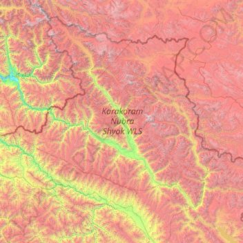
Name: Topografische Karte Nubra, Höhe, Relief.
Ort: Nubra, Leh district, Ladakh, 194401, India (33.97611 76.66317 35.67455 79.04537)
Durchschnittliche Höhe: 4’978 m
Minimale Höhe: 2’471 m
Maximale Höhe: 7’793 m
The main road access to Nubra is over Khardung La pass which is open throughout the year. The highest elevation of Khardung La is 5,359 m (17,582 ft), its status as the highest motorable road in the world is no longer accepted by most authorities. An alternative route, opened in 2008, crosses the Wari La from Sakti, to the east of Khardung La, connecting to the main Nubra road system via Agham and Khalsar along the Shyok River. There are also trekkable passes over the Ladakh Range from the Indus Valley at various points. Routes from Nubra to Baltistan and Yarkand, though historically important, have been closed since 1947 and 1950 respectively.
Andere topografische Karten
Klicken Sie auf eine Karte, um ihre Topografie, ihre Höhe und ihr Relief anzuzeigen.
Karakoram Pass
Karakoram Pass, Nubra, Leh District, Ladakh, India
Durchschnittliche Höhe: 5’521 m
Siachen Glacier
Siachen Glacier, Nubra, Leh district, Ladakh, India
Durchschnittliche Höhe: 5’448 m
Daulat Beg Oldi
Daulat Beg Oldi, Nubra, Leh district, Ladakh, India
Durchschnittliche Höhe: 5’085 m