
Topografische Karte Saint Tammany
Klicken Sie auf die Karte, um die Höhe anzuzeigen.
Über diese Karte
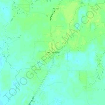
Name: Topografische Karte Saint Tammany, Höhe, Relief.
Ort: Saint Tammany, St. Tammany Parish, Louisiana, United States (30.37408 -89.91507 30.41408 -89.87507)
Durchschnittliche Höhe: 9 m
Minimale Höhe: 3 m
Maximale Höhe: 16 m
Andere topografische Karten
Klicken Sie auf eine Karte, um ihre Topografie, ihre Höhe und ihr Relief anzuzeigen.
Slidell
United States > Louisiana > St. Tammany Parish
Slidell is located at 30°16′45″N 89°46′40″W / 30.27917°N 89.77778°W / 30.27917; -89.77778 (30.279040, -89.777744), and has an elevation of 13 feet (4.0 m). It is in southeastern St. Tammany Parish, located approximately 3 miles (5 km) north of Lake Pontchartrain. The city forms part of the…
Durchschnittliche Höhe: 6 m
Mandeville
United States > Louisiana > St. Tammany Parish
Mandeville is located at 30°22′9″N 90°4′41″W / 30.36917°N 90.07806°W / 30.36917; -90.07806 (30.369282, -90.078006), and has an elevation of 7 feet (2.1 m). According to the United States Census Bureau, the city has a total area of 6.8 square miles (17.7 km2), of which 0.12 square miles…
Durchschnittliche Höhe: 6 m
Slidell
United States > Louisiana > St. Tammany Parish
Slidell is located at 30°16′45″N 89°46′40″W / 30.27917°N 89.77778°W / 30.27917; -89.77778 (30.279040, -89.777744), and has an elevation of 13 feet (4.0 m). It is in southeastern St. Tammany Parish, located approximately 3 miles (5 km) north of Lake Pontchartrain. The city forms part of the…
Durchschnittliche Höhe: 6 m