
Spenden
Rüste dich für dein nächstes Abenteuer:
Als Amazon-Partner verdient diese Seite an qualifizierten Käufen, ohne dass Ihnen zusätzliche Kosten entstehen.
Topografische Karte Myrtle Beach
Klicken Sie auf die Karte, um die Höhe anzuzeigen.
Spenden
Rüste dich für dein nächstes Abenteuer:
Als Amazon-Partner verdient diese Seite an qualifizierten Käufen, ohne dass Ihnen zusätzliche Kosten entstehen.
Myrtle Beach
Myrtle Beach features a predominantly flat topography characterized by its coastal plain setting. The area is situated just a few feet above sea level, with an average elevation of approximately 20 feet (6 meters), making it ideal for expansive sandy beaches and shallow tidal estuaries. The region is part of a continuous stretch of shoreline known as the Grand Strand, which spans about 60 miles (97 kilometers). This topography includes barrier islands and wetlands, providing a diverse habitat for various wildlife. The landscape is largely influenced by the Atlantic Ocean, with numerous inlets and swashes, like Wither's Swash, that define the coastal terrain.
Spenden
Rüste dich für dein nächstes Abenteuer:
Als Amazon-Partner verdient diese Seite an qualifizierten Käufen, ohne dass Ihnen zusätzliche Kosten entstehen.
Über diese Karte
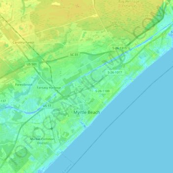
Name: Topografische Karte Myrtle Beach, Höhe, Relief.
Ort: Myrtle Beach, Horry County, South Carolina, United States (33.64738 -78.97802 33.79126 -78.78547)
Durchschnittliche Höhe: 6 m
Minimale Höhe: -5 m
Maximale Höhe: 16 m
Spenden
Rüste dich für dein nächstes Abenteuer:
Als Amazon-Partner verdient diese Seite an qualifizierten Käufen, ohne dass Ihnen zusätzliche Kosten entstehen.
Andere topografische Karten
Klicken Sie auf eine Karte, um ihre Topografie, ihre Höhe und ihr Relief anzuzeigen.
Windy Hill Beach
United States > South Carolina > Horry County > North Myrtle Beach
Durchschnittliche Höhe: 2 m
Spenden
Rüste dich für dein nächstes Abenteuer:
Als Amazon-Partner verdient diese Seite an qualifizierten Käufen, ohne dass Ihnen zusätzliche Kosten entstehen.
Cherry Grove Beach
United States > South Carolina > Horry County > North Myrtle Beach
Durchschnittliche Höhe: 1 m
Ingram Beach
United States > South Carolina > Horry County > North Myrtle Beach > Ocean Drive Beach
Durchschnittliche Höhe: 2 m
Spenden
Rüste dich für dein nächstes Abenteuer:
Als Amazon-Partner verdient diese Seite an qualifizierten Käufen, ohne dass Ihnen zusätzliche Kosten entstehen.
Barefoot Resort
United States > South Carolina > Horry County > North Myrtle Beach
Durchschnittliche Höhe: 4 m
Wild Wing Plantation
United States > South Carolina > Horry County > Conway
Durchschnittliche Höhe: 13 m
Cherry Grove Beach
United States > South Carolina > Horry County > North Myrtle Beach
Durchschnittliche Höhe: 1 m
Spenden
Rüste dich für dein nächstes Abenteuer:
Als Amazon-Partner verdient diese Seite an qualifizierten Käufen, ohne dass Ihnen zusätzliche Kosten entstehen.
Spenden
Rüste dich für dein nächstes Abenteuer:
Als Amazon-Partner verdient diese Seite an qualifizierten Käufen, ohne dass Ihnen zusätzliche Kosten entstehen.
Market Common District
United States > South Carolina > Horry County > Myrtle Beach
Durchschnittliche Höhe: 5 m
Seabrook Plantation
United States > South Carolina > Horry County > North Myrtle Beach
Durchschnittliche Höhe: 3 m
Spenden
Rüste dich für dein nächstes Abenteuer:
Als Amazon-Partner verdient diese Seite an qualifizierten Käufen, ohne dass Ihnen zusätzliche Kosten entstehen.