
Spenden
Rüste dich für dein nächstes Abenteuer:
Als Amazon-Partner verdient diese Seite an qualifizierten Käufen, ohne dass Ihnen zusätzliche Kosten entstehen.
Topografische Karte Rutland Town
Klicken Sie auf die Karte, um die Höhe anzuzeigen.
Spenden
Rüste dich für dein nächstes Abenteuer:
Als Amazon-Partner verdient diese Seite an qualifizierten Käufen, ohne dass Ihnen zusätzliche Kosten entstehen.
Rutland Town
The town was originally granted in 1761 by Governor Benning Wentworth as one of the New Hampshire Grants. He named it after John Manners, 3rd Duke of Rutland. It is also recorded that John Murray who was the first named proprietor and from Rutland named it. It was one of the most successful of those grants because of the excellent farmland and gentle topography.
Spenden
Rüste dich für dein nächstes Abenteuer:
Als Amazon-Partner verdient diese Seite an qualifizierten Käufen, ohne dass Ihnen zusätzliche Kosten entstehen.
Über diese Karte
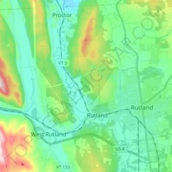
Name: Topografische Karte Rutland Town, Höhe, Relief.
Ort: Rutland Town, Rutland County, Vermont, United States (43.57174 -73.03284 43.66948 -72.93416)
Durchschnittliche Höhe: 229 m
Minimale Höhe: 107 m
Maximale Höhe: 605 m
Spenden
Rüste dich für dein nächstes Abenteuer:
Als Amazon-Partner verdient diese Seite an qualifizierten Käufen, ohne dass Ihnen zusätzliche Kosten entstehen.
Andere topografische Karten
Klicken Sie auf eine Karte, um ihre Topografie, ihre Höhe und ihr Relief anzuzeigen.
Spenden
Rüste dich für dein nächstes Abenteuer:
Als Amazon-Partner verdient diese Seite an qualifizierten Käufen, ohne dass Ihnen zusätzliche Kosten entstehen.
Saint Catherine Mountain
United States > Vermont > Rutland County > Wells
Durchschnittliche Höhe: 251 m
Spenden
Rüste dich für dein nächstes Abenteuer:
Als Amazon-Partner verdient diese Seite an qualifizierten Käufen, ohne dass Ihnen zusätzliche Kosten entstehen.
Billings Mobile Manor
United States > Vermont > Rutland County > Rutland City
Durchschnittliche Höhe: 211 m
South Wallingford
United States > Vermont > Rutland County > Wallingford
Durchschnittliche Höhe: 330 m
Spenden
Rüste dich für dein nächstes Abenteuer:
Als Amazon-Partner verdient diese Seite an qualifizierten Käufen, ohne dass Ihnen zusätzliche Kosten entstehen.
West Tinmouth
United States > Vermont > Rutland County > Tinmouth > West Tinmouth
Durchschnittliche Höhe: 419 m
Chittenden Reservoir
United States > Vermont > Rutland County > Chittenden
Durchschnittliche Höhe: 473 m