
Topografische Karte South Jordan
Interaktive Karte
Klicken Sie auf die Karte, um die Höhe anzuzeigen.
Über diese Karte
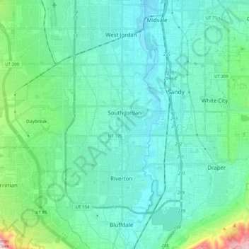
Name: Topografische Karte South Jordan, Höhe, Relief.
Ort: South Jordan, Salt Lake County, Utah, United States (40.53686 -112.06982 40.58212 -111.89457)
Durchschnittliche Höhe: 1’383 m
Minimale Höhe: 1’304 m
Maximale Höhe: 1’589 m
The relative flatness of South Jordan is due to lacustrine sediments of a pleistocene lake called Lake Bonneville. Lake Bonneville existed from 75,000 to 8,000 years ago; at its peak some 30,000 years ago, the lake reached an elevation of 5,200 feet (1,600 m) above sea level and had a surface area of 19,800 square miles (51,000 km2). The elevation of South Jordan ranges from approximately 4,300 feet (1,300 m) near the Jordan River in the east and rises gently to the foothills of the Oquirrh Mountains at 5,200 feet (1,600 m). A notable exception is a bluff at the western edge of the Daybreak Community which is an old sandbar of Lake Bonneville.