
Topografische Karte Băile Govora
Interaktive Karte
Klicken Sie auf die Karte, um die Höhe anzuzeigen.
Über diese Karte
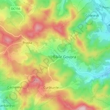
Name: Topografische Karte Băile Govora, Höhe, Relief.
Ort: Băile Govora, Vâlcea, Romania (45.05767 24.15786 45.10219 24.21843)
Durchschnittliche Höhe: 382 m
Minimale Höhe: 262 m
Maximale Höhe: 534 m
Andere topografische Karten
Klicken Sie auf eine Karte, um ihre Topografie, ihre Höhe und ihr Relief anzuzeigen.
Cainenii Mici
Cainenii Mici, Câineni, Vâlcea, 247087, Romania
Durchschnittliche Höhe: 510 m
Parcul Național Cozia
Parcul Național Cozia, Vâlcea, Romania
Durchschnittliche Höhe: 699 m
Băile Govora
Romania > Vâlcea > Băile Govora
Băile Govora, Valea Mare, Vâlcea, Romania
Durchschnittliche Höhe: 392 m