
Topografische Karte Idar-Oberstein
Interaktive Karte
Klicken Sie auf die Karte, um die Höhe anzuzeigen.
Über diese Karte
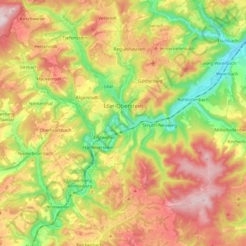
Name: Topografische Karte Idar-Oberstein, Höhe, Relief.
Durchschnittliche Höhe: 406 m
Minimale Höhe: 210 m
Maximale Höhe: 617 m
Idar-Oberstein/Göttschied Airfield lies north of the town between the constituent community of Göttschied and the municipalities of Gerach and Hintertiefenbach at an elevation of 480 m above sea level (1,575 feet). Its ICAO location indicator is EDRG. The grass landing strip's orientation is 06/24, and it is 650 m long and 50 m wide. The allowable landing weight is 2 000 kg; however, with PPR (“prior permission required”), aircraft of up to 3 700 kg may land. The airport is designed for helicopters, motor gliders, gliders, ultralights and, also with PPR, skydivers.
Andere topografische Karten
Klicken Sie auf eine Karte, um ihre Topografie, ihre Höhe und ihr Relief anzuzeigen.
Mittelreidenbach
Germany > Rhineland-Palatinate > Landkreis Birkenfeld
Mittelreidenbach, Herrstein-Rhaunen, Landkreis Birkenfeld, Rhineland-Palatinate, Germany
Durchschnittliche Höhe: 340 m
Hallenbad Idar-Oberstein
Germany > Rhineland-Palatinate > Landkreis Birkenfeld > Idar-Oberstein
Hallenbad Idar-Oberstein, 213, Hauptstraße, Idar, Idar-Oberstein, Landkreis Birkenfeld, Rhineland-Palatinate, 55743, Germany
Durchschnittliche Höhe: 343 m
Baumholder
Germany > Rhineland-Palatinate > Landkreis Birkenfeld
Baumholder, Landkreis Birkenfeld, Rhineland-Palatinate, 55774, Germany
Durchschnittliche Höhe: 451 m
Heimbach
Germany > Rhineland-Palatinate > Landkreis Birkenfeld
Heimbach, Baumholder, Landkreis Birkenfeld, Rhineland-Palatinate, Germany
Durchschnittliche Höhe: 412 m
Gollenberg
Germany > Rhineland-Palatinate > Landkreis Birkenfeld
Gollenberg, Birkenfeld, Landkreis Birkenfeld, Rhineland-Palatinate, Germany
Durchschnittliche Höhe: 466 m