
Topografische Karte Northallerton
Interaktive Karte
Klicken Sie auf die Karte, um die Höhe anzuzeigen.
Über diese Karte
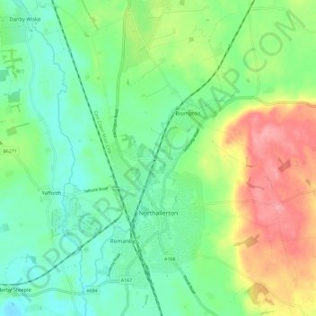
Name: Topografische Karte Northallerton, Höhe, Relief.
Durchschnittliche Höhe: 56 m
Minimale Höhe: 23 m
Maximale Höhe: 116 m
Andere topografische Karten
Klicken Sie auf eine Karte, um ihre Topografie, ihre Höhe und ihr Relief anzuzeigen.
Thornton-on-the-Hill
United Kingdom > England > North Yorkshire > Hambleton
Thornton-on-the-Hill, Hambleton, North Yorkshire, England, United Kingdom
Durchschnittliche Höhe: 80 m
Stokesley
United Kingdom > England > North Yorkshire > Hambleton
Stokesley, Hambleton, North Yorkshire, England, United Kingdom
Durchschnittliche Höhe: 74 m
Exelby, Leeming and Londonderry
United Kingdom > England > North Yorkshire > Hambleton
Exelby, Leeming and Londonderry, Hambleton, North Yorkshire, Yorkshire and the Humber, England, United Kingdom
Durchschnittliche Höhe: 35 m
Great Ayton
United Kingdom > England > North Yorkshire > Hambleton > Great Ayton
Great Ayton, Hambleton, North Yorkshire, Yorkshire and the Humber, England, United Kingdom
Durchschnittliche Höhe: 119 m
Howe
United Kingdom > England > North Yorkshire > Hambleton > Skipton on Swale > Howe
Howe, Skipton on Swale, Hambleton, North Yorkshire, Yorkshire and the Humber, England, YO7 4HU, United Kingdom
Durchschnittliche Höhe: 28 m