
Spenden
Rüste dich für dein nächstes Abenteuer:
Als Amazon-Partner verdient diese Seite an qualifizierten Käufen, ohne dass Ihnen zusätzliche Kosten entstehen.
Topografische Karte Decatur
Klicken Sie auf die Karte, um die Höhe anzuzeigen.
Spenden
Rüste dich für dein nächstes Abenteuer:
Als Amazon-Partner verdient diese Seite an qualifizierten Käufen, ohne dass Ihnen zusätzliche Kosten entstehen.
Decatur
According to the United States Census Bureau, the city has a total area of 8.5 square miles (22 km2), all land. The highest point of elevation in the county is the courthouse site. As with ancient hill towns in Europe, the frontier settlement was developed on high ground for defensive purposes, so European settlers could see and ward off attacks or raids, in this case by Native Americans.
Spenden
Rüste dich für dein nächstes Abenteuer:
Als Amazon-Partner verdient diese Seite an qualifizierten Käufen, ohne dass Ihnen zusätzliche Kosten entstehen.
Über diese Karte
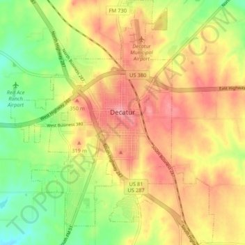
Name: Topografische Karte Decatur, Höhe, Relief.
Ort: Decatur, Wise County, Texas, 76234, United States (33.19772 -97.62301 33.26524 -97.55589)
Durchschnittliche Höhe: 297 m
Minimale Höhe: 245 m
Maximale Höhe: 340 m
Spenden
Rüste dich für dein nächstes Abenteuer:
Als Amazon-Partner verdient diese Seite an qualifizierten Käufen, ohne dass Ihnen zusätzliche Kosten entstehen.