
Topografische Karte Fultondale
Interaktive Karte
Klicken Sie auf die Karte, um die Höhe anzuzeigen.
Über diese Karte
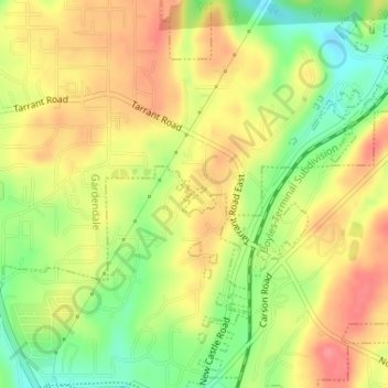
Name: Topografische Karte Fultondale, Höhe, Relief.
Ort: Fultondale, Jefferson County, Alabama, United States (33.63460 -86.78918 33.63555 -86.78769)
Durchschnittliche Höhe: 190 m
Minimale Höhe: 147 m
Maximale Höhe: 224 m
Due to difficult topography, for many years Fultondale was limited in its ability to grow. However, as technology improved, the ability to convert what had been difficult to unusable land for retail and commercial purposes improved. Besides the retail development of Colonial Promenade, other retail development nearby includes Lowe's and various chain restaurants such as O'Charley's and Outback Steakhouse. Other older, more mature business establishments line US 31 in the center of the community including supermarkets, casual fast food, banks, a bowling alley and skating rink.
Andere topografische Karten
Klicken Sie auf eine Karte, um ihre Topografie, ihre Höhe und ihr Relief anzuzeigen.
Frances Heights
United States > Alabama > Jefferson County > Fultondale
Frances Heights, Fultondale, Jefferson County, Alabama, 35068, United States
Durchschnittliche Höhe: 174 m