
Spenden
Rüste dich für dein nächstes Abenteuer:
Als Amazon-Partner verdient diese Seite an qualifizierten Käufen, ohne dass Ihnen zusätzliche Kosten entstehen.
Topografische Karte Adwa
Klicken Sie auf die Karte, um die Höhe anzuzeigen.
Spenden
Rüste dich für dein nächstes Abenteuer:
Als Amazon-Partner verdient diese Seite an qualifizierten Käufen, ohne dass Ihnen zusätzliche Kosten entstehen.
Adwa
Adwa (Tigrinya: ዓድዋ; Amharic: ዐድዋ; also spelled Adowa or Aduwa) is a town and separate woreda in Tigray Region, Ethiopia. It is best known as the community closest to the site of the 1896 Battle of Adwa, in which Ethiopian soldiers defeated Italian troops, thus being one of the few African nations to thwart European colonialism. Located in the Central Zone of the Tigray Region, Adwa has a longitude and latitude of 14°10′N 38°54′E / 14.167°N 38.900°E / 14.167; 38.900, and an elevation of 1907 meters. Adwa is surrounded by Adwa woreda.
Spenden
Rüste dich für dein nächstes Abenteuer:
Als Amazon-Partner verdient diese Seite an qualifizierten Käufen, ohne dass Ihnen zusätzliche Kosten entstehen.
Über diese Karte
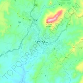
Name: Topografische Karte Adwa, Höhe, Relief.
Ort: Adwa, Central Tigray, Tigray, Ethiopia (14.12707 38.85116 14.20707 38.93116)
Durchschnittliche Höhe: 1’962 m
Minimale Höhe: 1’821 m
Maximale Höhe: 2’460 m
Spenden
Rüste dich für dein nächstes Abenteuer:
Als Amazon-Partner verdient diese Seite an qualifizierten Käufen, ohne dass Ihnen zusätzliche Kosten entstehen.
Andere topografische Karten
Klicken Sie auf eine Karte, um ihre Topografie, ihre Höhe und ihr Relief anzuzeigen.
Mek'elē
Mekelle (Tigrinya: መቐለ), or Mekele, is a special zone and capital of the Tigray Region of Ethiopia. Mekelle was formerly the capital of Enderta awraja in Tigray. It is located around 780 kilometres (480 mi) north of the Ethiopian capital Addis Ababa, with an elevation of 2,254 metres (7,395 ft) above sea…
Durchschnittliche Höhe: 2’090 m
Alamata
Alamata (Tigrinya: ኣላማጣ ) is a town in the Tigray Region of Ethiopia. Located in the Debubawi (Southern) zone of Tigray it has a latitude and longitude of 12°25′N 39°33′E / 12.417°N 39.550°E / 12.417; 39.550 and an elevation of 1,520 metres (4,990 ft) above sea level and is located…
Durchschnittliche Höhe: 1’574 m
Spenden
Rüste dich für dein nächstes Abenteuer:
Als Amazon-Partner verdient diese Seite an qualifizierten Käufen, ohne dass Ihnen zusätzliche Kosten entstehen.
Mek'elē
Mekelle (Tigrinya: መቐለ), or Mek'ele, is a special zone and capital of the Tigray Region of Ethiopia. Mekelle was formerly the capital of Enderta awraja in Tigray. It is located around 780 kilometres (480 mi) north of the Ethiopian capital Addis Ababa, with an elevation of 2,254 metres (7,395 ft) above…
Durchschnittliche Höhe: 2’090 m
Spenden
Rüste dich für dein nächstes Abenteuer:
Als Amazon-Partner verdient diese Seite an qualifizierten Käufen, ohne dass Ihnen zusätzliche Kosten entstehen.