
Spenden
Rüste dich für dein nächstes Abenteuer:
Als Amazon-Partner verdient diese Seite an qualifizierten Käufen, ohne dass Ihnen zusätzliche Kosten entstehen.
Topografische Karte Nathdwara
Klicken Sie auf die Karte, um die Höhe anzuzeigen.
Spenden
Rüste dich für dein nächstes Abenteuer:
Als Amazon-Partner verdient diese Seite an qualifizierten Käufen, ohne dass Ihnen zusätzliche Kosten entstehen.
Nathdwara
Nathdwara is located at 24°56′N 73°49′E / 24.93°N 73.82°E / 24.93; 73.82. It has an average elevation of 584 metres (1919 ft). Located just 48 km north-east of Udaipur in Rajasthan, this town is easily reached by air, road or nearest rail-head.
Spenden
Rüste dich für dein nächstes Abenteuer:
Als Amazon-Partner verdient diese Seite an qualifizierten Käufen, ohne dass Ihnen zusätzliche Kosten entstehen.
Über diese Karte
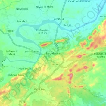
Name: Topografische Karte Nathdwara, Höhe, Relief.
Durchschnittliche Höhe: 590 m
Minimale Höhe: 538 m
Maximale Höhe: 713 m
Spenden
Rüste dich für dein nächstes Abenteuer:
Als Amazon-Partner verdient diese Seite an qualifizierten Käufen, ohne dass Ihnen zusätzliche Kosten entstehen.