
Topografische Karte Newkirk
Klicken Sie auf die Karte, um die Höhe anzuzeigen.
Newkirk
Newkirk's elevation is 1,152 feet (351 m). It is on mostly flat terrain with no large watercourses nearby, and at the boundary between two ecoregions: the Central Great Plains and the Flint Hills. West of the town on the Great Plains, the countryside is rich agricultural land, especially for wheat, soybeans, and cattle. East of town, the Flint Hills' terrain is more rugged and rocky and is primarily used for cattle ranching. Natural vegetation is mostly prairie, but stream valleys often have forests of cottonwood, oak, elm, ash, pecan, sycamore, and other species. Scrub oak and red cedar dot hillsides. Wildlife is abundant, including whitetail deer, turkey, bobwhite quail, coyote, bobcat, and waterfowl. A cougar attack on a person seven miles (11 km) east of Newkirk was reported in 2002.
Über diese Karte
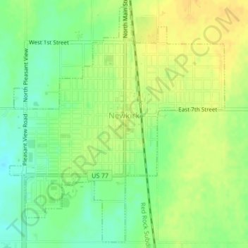
Name: Topografische Karte Newkirk, Höhe, Relief.
Ort: Newkirk, Kay County, Oklahoma, 74647, United States (36.86857 -97.06925 36.89420 -97.04001)
Durchschnittliche Höhe: 350 m
Minimale Höhe: 335 m
Maximale Höhe: 361 m
Andere topografische Karten
Klicken Sie auf eine Karte, um ihre Topografie, ihre Höhe und ihr Relief anzuzeigen.
Ponca City
United States > Oklahoma > Kay County > Ponca City > Ponca City
Durchschnittliche Höhe: 302 m