
Spenden
Rüste dich für dein nächstes Abenteuer:
Als Amazon-Partner verdient diese Seite an qualifizierten Käufen, ohne dass Ihnen zusätzliche Kosten entstehen.
Topografische Karte Stuarts Draft
Klicken Sie auf die Karte, um die Höhe anzuzeigen.
Spenden
Rüste dich für dein nächstes Abenteuer:
Als Amazon-Partner verdient diese Seite an qualifizierten Käufen, ohne dass Ihnen zusätzliche Kosten entstehen.
Stuarts Draft
Stuarts Draft includes several natural and man-made ponds. Lake Wilda is Green Pond is a naturally occurring high-elevation pond on the Big Levels Ridge. It is five acres in size during the wet season. The Virginia Commission of Game and Inland Fisheries constructed the Maple Flats Ponds in the late 1950s to serve migrating waterfowl. However, this project failed because water levels were too low seasonally. These ponds are now stocked with bass, bluegill, and catfish for recreational use, There are naturally occurring sinkhole ponds near the Maple Flats Ponds, including Spring Pond and Twin Ponds that are home to a botanically significant range of plants.
Spenden
Rüste dich für dein nächstes Abenteuer:
Als Amazon-Partner verdient diese Seite an qualifizierten Käufen, ohne dass Ihnen zusätzliche Kosten entstehen.
Über diese Karte
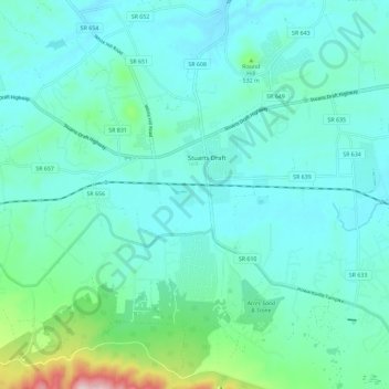
Name: Topografische Karte Stuarts Draft, Höhe, Relief.
Durchschnittliche Höhe: 457 m
Minimale Höhe: 401 m
Maximale Höhe: 756 m
Spenden
Rüste dich für dein nächstes Abenteuer:
Als Amazon-Partner verdient diese Seite an qualifizierten Käufen, ohne dass Ihnen zusätzliche Kosten entstehen.
Andere topografische Karten
Klicken Sie auf eine Karte, um ihre Topografie, ihre Höhe und ihr Relief anzuzeigen.
Spenden
Rüste dich für dein nächstes Abenteuer:
Als Amazon-Partner verdient diese Seite an qualifizierten Käufen, ohne dass Ihnen zusätzliche Kosten entstehen.
Spenden
Rüste dich für dein nächstes Abenteuer:
Als Amazon-Partner verdient diese Seite an qualifizierten Käufen, ohne dass Ihnen zusätzliche Kosten entstehen.
Spenden
Rüste dich für dein nächstes Abenteuer:
Als Amazon-Partner verdient diese Seite an qualifizierten Käufen, ohne dass Ihnen zusätzliche Kosten entstehen.