
Spenden
Rüste dich für dein nächstes Abenteuer:
Als Amazon-Partner verdient diese Seite an qualifizierten Käufen, ohne dass Ihnen zusätzliche Kosten entstehen.
Topografische Karte Swannanoa
Klicken Sie auf die Karte, um die Höhe anzuzeigen.
Spenden
Rüste dich für dein nächstes Abenteuer:
Als Amazon-Partner verdient diese Seite an qualifizierten Käufen, ohne dass Ihnen zusätzliche Kosten entstehen.
Über diese Karte
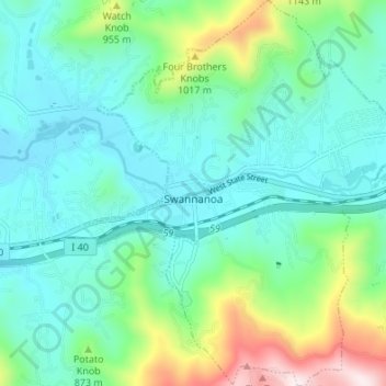
Name: Topografische Karte Swannanoa, Höhe, Relief.
Ort: Swannanoa, Buncombe County, North Carolina, United States (35.57318 -82.42260 35.62807 -82.36641)
Durchschnittliche Höhe: 796 m
Minimale Höhe: 645 m
Maximale Höhe: 1’302 m
Spenden
Rüste dich für dein nächstes Abenteuer:
Als Amazon-Partner verdient diese Seite an qualifizierten Käufen, ohne dass Ihnen zusätzliche Kosten entstehen.
Andere topografische Karten
Klicken Sie auf eine Karte, um ihre Topografie, ihre Höhe und ihr Relief anzuzeigen.
Haw Creek Park
United States > North Carolina > Buncombe County > Asheville > Dogwood Grove
Durchschnittliche Höhe: 666 m
Spenden
Rüste dich für dein nächstes Abenteuer:
Als Amazon-Partner verdient diese Seite an qualifizierten Käufen, ohne dass Ihnen zusätzliche Kosten entstehen.
Arden
United States > North Carolina > Buncombe County > Asheville > Royal Pines
Durchschnittliche Höhe: 693 m
Spenden
Rüste dich für dein nächstes Abenteuer:
Als Amazon-Partner verdient diese Seite an qualifizierten Käufen, ohne dass Ihnen zusätzliche Kosten entstehen.
Biltmore Village
United States > North Carolina > Buncombe County > Asheville
Durchschnittliche Höhe: 642 m
Dogwood Grove
United States > North Carolina > Buncombe County > Asheville
Durchschnittliche Höhe: 700 m
Spenden
Rüste dich für dein nächstes Abenteuer:
Als Amazon-Partner verdient diese Seite an qualifizierten Käufen, ohne dass Ihnen zusätzliche Kosten entstehen.
Craggy Pinnacle Summit
United States > North Carolina > Buncombe County
Durchschnittliche Höhe: 1’510 m
Spenden
Rüste dich für dein nächstes Abenteuer:
Als Amazon-Partner verdient diese Seite an qualifizierten Käufen, ohne dass Ihnen zusätzliche Kosten entstehen.
Last house on the Hare RDG
United States > North Carolina > Buncombe County
Durchschnittliche Höhe: 754 m
Spenden
Rüste dich für dein nächstes Abenteuer:
Als Amazon-Partner verdient diese Seite an qualifizierten Käufen, ohne dass Ihnen zusätzliche Kosten entstehen.
Spenden
Rüste dich für dein nächstes Abenteuer:
Als Amazon-Partner verdient diese Seite an qualifizierten Käufen, ohne dass Ihnen zusätzliche Kosten entstehen.
Royal Pines
United States > North Carolina > Buncombe County > Asheville
Royal Pines is located in southern Buncombe County at 35°28′39″N 82°30′35″W / 35.47750°N 82.50972°W / 35.47750; -82.50972 (35.477386, -82.509833). It is bordered to the west by U.S. Route 25A and the city limits of Asheville, and to the northeast by Mills Gap Road. Brown Mountain, with an…
Durchschnittliche Höhe: 700 m
Redwood Village
United States > North Carolina > Buncombe County > Asheville
Durchschnittliche Höhe: 657 m
Aston Park
United States > North Carolina > Buncombe County > Asheville > River Arts District
Durchschnittliche Höhe: 641 m
Spenden
Rüste dich für dein nächstes Abenteuer:
Als Amazon-Partner verdient diese Seite an qualifizierten Käufen, ohne dass Ihnen zusätzliche Kosten entstehen.