
Topografische Karte Harriet Cove
Interaktive Karte
Klicken Sie auf die Karte, um die Höhe anzuzeigen.
Über diese Karte
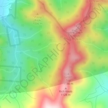
Name: Topografische Karte Harriet Cove, Höhe, Relief.
Durchschnittliche Höhe: 919 m
Minimale Höhe: 720 m
Maximale Höhe: 1’159 m
Andere topografische Karten
Klicken Sie auf eine Karte, um ihre Topografie, ihre Höhe und ihr Relief anzuzeigen.
Ridgecrest
United States > North Carolina > Buncombe County
Ridgecrest, Buncombe County, North Carolina, 28770, United States
Durchschnittliche Höhe: 875 m
Murry Hill Park
United States > North Carolina > Buncombe County > Asheville > River Arts District
Murry Hill Park, River Arts District, Asheville, Buncombe County, North Carolina, 28801, United States
Durchschnittliche Höhe: 639 m
Redwood Village
United States > North Carolina > Buncombe County > Asheville > Redwood Village
Redwood Village, Asheville, Buncombe County, North Carolina, 28805, United States
Durchschnittliche Höhe: 657 m
Asheville
United States > North Carolina > Buncombe County
Asheville, Buncombe County, North Carolina, United States
Durchschnittliche Höhe: 727 m