
Topografische Karte Thousand Springs
Interaktive Karte
Klicken Sie auf die Karte, um die Höhe anzuzeigen.
Über diese Karte
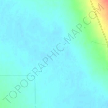
Name: Topografische Karte Thousand Springs, Höhe, Relief.
Ort: Thousand Springs, Custer County, Idaho, United States (44.13709 -113.92342 44.13719 -113.92332)
Durchschnittliche Höhe: 1’922 m
Minimale Höhe: 1’914 m
Maximale Höhe: 1’964 m
Andere topografische Karten
Klicken Sie auf eine Karte, um ihre Topografie, ihre Höhe und ihr Relief anzuzeigen.
Stanley Lake
United States > Idaho > Custer County
Stanley Lake, Custer County, Idaho, United States
Durchschnittliche Höhe: 2’075 m
Pine Summit
United States > Idaho > Custer County
Pine Summit, Custer County, Idaho, United States
Durchschnittliche Höhe: 2’315 m
Stanley
United States > Idaho > Custer County
Stanley, Custer County, Idaho, United States
Durchschnittliche Höhe: 1’931 m
Challis
United States > Idaho > Custer County
Challis, Custer County, Idaho, United States
Durchschnittliche Höhe: 1’626 m
Borah Peak
United States > Idaho > Custer County
Borah Peak, Custer County, Idaho, United States
Durchschnittliche Höhe: 3’280 m
Lost River
United States > Idaho > Custer County
Lost River, Custer County, Idaho, United States
Durchschnittliche Höhe: 2’198 m
Redfish Lake
United States > Idaho > Custer County
Redfish Lake, Custer County, Idaho, United States
Durchschnittliche Höhe: 2’144 m