
Spenden
Rüste dich für dein nächstes Abenteuer:
Als Amazon-Partner verdient diese Seite an qualifizierten Käufen, ohne dass Ihnen zusätzliche Kosten entstehen.
Topografische Karte Elmore
Klicken Sie auf die Karte, um die Höhe anzuzeigen.
Spenden
Rüste dich für dein nächstes Abenteuer:
Als Amazon-Partner verdient diese Seite an qualifizierten Käufen, ohne dass Ihnen zusätzliche Kosten entstehen.
Elmore
Elmore is in southeastern Lamoille County, bordered to the south and east by Washington County. A small portion of the town border on the east is with Caledonia County. According to the United States Census Bureau, the town has a total area of 39.7 square miles (102.7 km2), of which 39.1 square miles (101.3 km2) are land and 0.54 square miles (1.4 km2), or 1.38%, are water. Lake Elmore is in the northwest corner of the town, and drains north via Elmore Pond Brook toward the Lamoille River. Elmore village sits at the northern end of the lake. The Worcester Mountains are on the western side of the town. Mt. Elmore, at the northern end of the range, rises to an elevation of 2,608 feet (795 m) to the west of Lake Elmore.
Spenden
Rüste dich für dein nächstes Abenteuer:
Als Amazon-Partner verdient diese Seite an qualifizierten Käufen, ohne dass Ihnen zusätzliche Kosten entstehen.
Über diese Karte
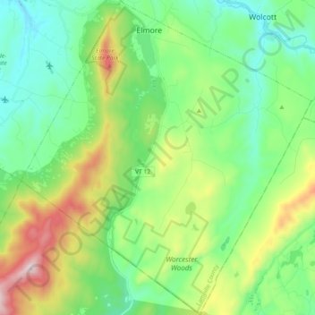
Name: Topografische Karte Elmore, Höhe, Relief.
Ort: Elmore, Lamoille County, Vermont, 05657, United States (44.42398 -72.59728 44.55341 -72.42981)
Durchschnittliche Höhe: 422 m
Minimale Höhe: 188 m
Maximale Höhe: 986 m
Spenden
Rüste dich für dein nächstes Abenteuer:
Als Amazon-Partner verdient diese Seite an qualifizierten Käufen, ohne dass Ihnen zusätzliche Kosten entstehen.
Andere topografische Karten
Klicken Sie auf eine Karte, um ihre Topografie, ihre Höhe und ihr Relief anzuzeigen.
Spenden
Rüste dich für dein nächstes Abenteuer:
Als Amazon-Partner verdient diese Seite an qualifizierten Käufen, ohne dass Ihnen zusätzliche Kosten entstehen.
Spenden
Rüste dich für dein nächstes Abenteuer:
Als Amazon-Partner verdient diese Seite an qualifizierten Käufen, ohne dass Ihnen zusätzliche Kosten entstehen.