
Topografische Karte Old Stone Fort State Archaeological Park
Interaktive Karte
Klicken Sie auf die Karte, um die Höhe anzuzeigen.
Über diese Karte
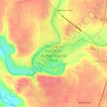
Name: Topografische Karte Old Stone Fort State Archaeological Park, Höhe, Relief.
Durchschnittliche Höhe: 316 m
Minimale Höhe: 268 m
Maximale Höhe: 339 m
The Duck River system spills over a limestone-rich shelf of the western Cumberland Plateau known as the Highland Rim. As the Duck and Little Duck approach their convergence, they rapidly drop in elevation, and have cut relatively deep gorges around the peninsula upon which the ancient structure is located. Both gorges are highlighted by a series of substantial waterfalls and whitewater rapids. The natural waterpower in these two gorges attracted entrepreneurs and millwrights throughout the 19th century.
Andere topografische Karten
Klicken Sie auf eine Karte, um ihre Topografie, ihre Höhe und ihr Relief anzuzeigen.
Glenview
United States > Tennessee > Coffee County > Manchester
Glenview, Manchester, Coffee County, Middle Tennessee, Tennessee, 37355, United States
Durchschnittliche Höhe: 322 m
White Oaks
United States > Tennessee > Coffee County > Manchester
White Oaks, Manchester, Coffee County, Tennessee, 38505, United States
Durchschnittliche Höhe: 325 m
Belmont
United States > Tennessee > Coffee County > Manchester
Belmont, Manchester, Coffee County, Middle Tennessee, Tennessee, United States
Durchschnittliche Höhe: 320 m
Royal Oaks
United States > Tennessee > Coffee County > Manchester > Royal Oaks
Royal Oaks, Manchester, Coffee County, Tennessee, 38505, United States
Durchschnittliche Höhe: 326 m
Westwood
United States > Tennessee > Coffee County > Manchester > Westwood
Westwood, Manchester, Coffee County, Tennessee, 37183:37355, United States
Durchschnittliche Höhe: 322 m