
Topografische Karte Kerguelen
Interaktive Karte
Klicken Sie auf die Karte, um die Höhe anzuzeigen.
Über diese Karte
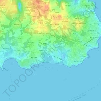
Name: Topografische Karte Kerguelen, Höhe, Relief.
Durchschnittliche Höhe: 10 m
Minimale Höhe: -1 m
Maximale Höhe: 39 m
Andere topografische Karten
Klicken Sie auf eine Karte, um ihre Topografie, ihre Höhe und ihr Relief anzuzeigen.
Les Quatre Chemins
France > Bretagne > Morbihan > Larmor-Plage
Les Quatre Chemins, Larmor-Plage, Lorient, Morbihan, Bretagne, France métropolitaine, 56260, France
Durchschnittliche Höhe: 10 m
Le Bourrigo
France > Bretagne > Morbihan > Larmor-Plage > Le Bourrigo
Le Bourrigo, Larmor-Plage, Lorient, Morbihan, Bretagne, France métropolitaine, 56260, France
Durchschnittliche Höhe: 7 m
Locqueltas
France > Bretagne > Morbihan > Larmor-Plage
Locqueltas, Larmor-Plage, Lorient, Morbihan, Bretagne, France métropolitaine, 56260, France
Durchschnittliche Höhe: 6 m
Kerpape
France > Bretagne > Morbihan > Larmor-Plage
Kerpape, Larmor-Plage, Lorient, Morbihan, Bretagne, France métropolitaine, 56260, France
Durchschnittliche Höhe: 10 m
Le Bourg
France > Bretagne > Morbihan > Larmor-Plage
Le Bourg, Larmor-Plage, Lorient, Morbihan, Bretagne, France métropolitaine, 56260, France
Durchschnittliche Höhe: 6 m