
Topografische Karte Colney Heath
Klicken Sie auf die Karte, um die Höhe anzuzeigen.
Über diese Karte
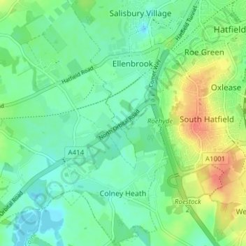
Name: Topografische Karte Colney Heath, Höhe, Relief.
Durchschnittliche Höhe: 81 m
Minimale Höhe: 66 m
Maximale Höhe: 111 m
Andere topografische Karten
Klicken Sie auf eine Karte, um ihre Topografie, ihre Höhe und ihr Relief anzuzeigen.
St Albans
United Kingdom > England > Hertfordshire > St Albans
St Albans was an ancient borough created following the dissolution of the monastery in 1539. It consisted of the ancient parish of St Albans (also known as the Abbey parish) and parts of St Michael and St Peter. The municipal corporation was reformed by the Municipal Corporations Act 1835 and the boundary was…
Durchschnittliche Höhe: 100 m
Highfield Park
United Kingdom > England > Hertfordshire > St Albans > Colney Heath
Durchschnittliche Höhe: 87 m
Nomansland
United Kingdom > England > Hertfordshire > St Albans > Sandridge
Durchschnittliche Höhe: 105 m
Blackmore End
United Kingdom > England > Hertfordshire > St Albans > Wheathampstead
Durchschnittliche Höhe: 114 m
Amwell
United Kingdom > England > Hertfordshire > St Albans > Wheathampstead
Durchschnittliche Höhe: 106 m
Lower Gustard Wood
United Kingdom > England > Hertfordshire > St Albans > Wheathampstead
Durchschnittliche Höhe: 112 m
Smug Oak
United Kingdom > England > Hertfordshire > St Albans > Bricket Wood
Durchschnittliche Höhe: 78 m
Tyttenhanger
United Kingdom > England > Hertfordshire > St Albans > Colney Heath
Durchschnittliche Höhe: 83 m
Serge Hill
United Kingdom > England > Hertfordshire > St Albans > Bedmond
Durchschnittliche Höhe: 114 m
Napsbury Park
United Kingdom > England > Hertfordshire > St Albans > London Colney
Durchschnittliche Höhe: 78 m
Serge Hill
United Kingdom > England > Hertfordshire > St Albans > Bedmond
Durchschnittliche Höhe: 114 m