
Topografische Karte Goose Prairie
Interaktive Karte
Klicken Sie auf die Karte, um die Höhe anzuzeigen.
Über diese Karte
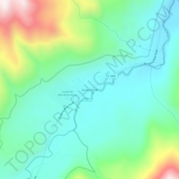
Name: Topografische Karte Goose Prairie, Höhe, Relief.
Ort: Goose Prairie, Yakima County, Washington, United States (46.87522 -121.28701 46.91522 -121.24701)
Durchschnittliche Höhe: 1’156 m
Minimale Höhe: 943 m
Maximale Höhe: 1’746 m
Andere topografische Karten
Klicken Sie auf eine Karte, um ihre Topografie, ihre Höhe und ihr Relief anzuzeigen.
Selah
United States > Washington > Yakima County
Selah, Yakima County, Washington, 98942, United States
Durchschnittliche Höhe: 395 m
Ahtanum
United States > Washington > Yakima County
Ahtanum, Yakima County, Washington, United States
Durchschnittliche Höhe: 424 m
Gleed
United States > Washington > Yakima County
Gleed, Yakima County, Washington, United States
Durchschnittliche Höhe: 424 m
Yakima
United States > Washington > Yakima County > Yakima
Yakima, Yakima County, Washington, 98901, United States
Durchschnittliche Höhe: 467 m
Pleasant Hill
United States > Washington > Yakima County > Selah
Pleasant Hill, Selah, Yakima County, Washington, 98942, United States
Durchschnittliche Höhe: 416 m
Sunnyside
United States > Washington > Yakima County > Sunnyside > Sunnyside
Sunnyside, Yakima County, Washington, 98944, United States
Durchschnittliche Höhe: 239 m
Grandview
United States > Washington > Yakima County
Grandview, Yakima County, Washington, 98930, United States
Durchschnittliche Höhe: 237 m
Naches
United States > Washington > Yakima County
Naches, Yakima County, Washington, United States
Durchschnittliche Höhe: 470 m
Bumping Lake
United States > Washington > Yakima County
Bumping Lake, Yakima County, Washington, United States
Durchschnittliche Höhe: 1’236 m