
Topografische Karte Kettering
Interaktive Karte
Klicken Sie auf die Karte, um die Höhe anzuzeigen.
Über diese Karte
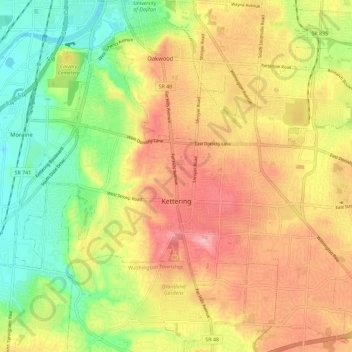
Name: Topografische Karte Kettering, Höhe, Relief.
Ort: Kettering, Montgomery County, Ohio, United States (39.65495 -84.21473 39.73652 -84.09999)
Durchschnittliche Höhe: 275 m
Minimale Höhe: 213 m
Maximale Höhe: 334 m
Andere topografische Karten
Klicken Sie auf eine Karte, um ihre Topografie, ihre Höhe und ihr Relief anzuzeigen.
Patterson
United States > Ohio > Montgomery County > Dayton
Patterson, Dayton, Montgomery County, Ohio, 45408, United States
Durchschnittliche Höhe: 233 m
Oakland
United States > Ohio > Montgomery County > Dayton
Oakland, Dayton, Montgomery County, Ohio, 45403, United States
Durchschnittliche Höhe: 269 m
Washington Township
United States > Ohio > Montgomery County
Washington Township, Montgomery County, Ohio, United States
Durchschnittliche Höhe: 285 m
North Riverdale
United States > Ohio > Montgomery County > Dayton
North Riverdale, Dayton, Montgomery County, Ohio, 45405, United States
Durchschnittliche Höhe: 254 m
Shakertown
United States > Ohio > Montgomery County > Kettering
Shakertown, Kettering, Montgomery County, Ohio, 45420, United States
Durchschnittliche Höhe: 282 m
Centerville
United States > Ohio > Montgomery County
Centerville, Montgomery County, Ohio, United States
Durchschnittliche Höhe: 287 m
Miami Township
United States > Ohio > Montgomery County
Miami Township, Montgomery County, Ohio, United States
Durchschnittliche Höhe: 272 m
Hearthstone
United States > Ohio > Montgomery County > Dayton
Hearthstone, Dayton, Montgomery County, Ohio, 45420, United States
Durchschnittliche Höhe: 273 m
Dayton
United States > Ohio > Montgomery County
Dayton, Montgomery County, Ohio, United States
Durchschnittliche Höhe: 270 m
Dayton
United States > Ohio > Montgomery County > Dayton
Dayton, Montgomery County, Ohio, 45423, United States
Durchschnittliche Höhe: 270 m