
Spenden
Rüste dich für dein nächstes Abenteuer:
Als Amazon-Partner verdient diese Seite an qualifizierten Käufen, ohne dass Ihnen zusätzliche Kosten entstehen.
Topografische Karte Mashpee
Klicken Sie auf die Karte, um die Höhe anzuzeigen.
Spenden
Rüste dich für dein nächstes Abenteuer:
Als Amazon-Partner verdient diese Seite an qualifizierten Käufen, ohne dass Ihnen zusätzliche Kosten entstehen.
Mashpee
Like all towns on the Cape, Mashpee's topography is that of sandy soil, small ponds and inlets, surrounded by the pines and oaks indigenous to the area. The town's shoreline is framed by Waquoit Bay to the west and Popponesset Bay to the east, with several rivers, brooks and small ponds in the area. The town contains South Cape Beach State Park along Dead Neck and Waquoit Bay, and the Lowell Holly Reservation, comprising the land between Wakeby and Mashpee Ponds.
Spenden
Rüste dich für dein nächstes Abenteuer:
Als Amazon-Partner verdient diese Seite an qualifizierten Käufen, ohne dass Ihnen zusätzliche Kosten entstehen.
Über diese Karte
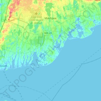
Name: Topografische Karte Mashpee, Höhe, Relief.
Durchschnittliche Höhe: 10 m
Minimale Höhe: -11 m
Maximale Höhe: 72 m
Spenden
Rüste dich für dein nächstes Abenteuer:
Als Amazon-Partner verdient diese Seite an qualifizierten Käufen, ohne dass Ihnen zusätzliche Kosten entstehen.
Andere topografische Karten
Klicken Sie auf eine Karte, um ihre Topografie, ihre Höhe und ihr Relief anzuzeigen.
Craigville
United States > Massachusetts > Barnstable County > Centerville
Durchschnittliche Höhe: 6 m
Opeechee Heights Beach
United States > Massachusetts > Barnstable County > Barnstable > Centerville
Durchschnittliche Höhe: 14 m
Spenden
Rüste dich für dein nächstes Abenteuer:
Als Amazon-Partner verdient diese Seite an qualifizierten Käufen, ohne dass Ihnen zusätzliche Kosten entstehen.
Cobbs Village
United States > Massachusetts > Barnstable County > Barnstable
Durchschnittliche Höhe: 9 m
West Falmouth
United States > Massachusetts > Barnstable County > Falmouth
Durchschnittliche Höhe: 13 m
Spenden
Rüste dich für dein nächstes Abenteuer:
Als Amazon-Partner verdient diese Seite an qualifizierten Käufen, ohne dass Ihnen zusätzliche Kosten entstehen.
Miller Hill
United States > Massachusetts > Barnstable County > Provincetown
Durchschnittliche Höhe: 5 m
South Brewster
United States > Massachusetts > Barnstable County > Brewster
Durchschnittliche Höhe: 26 m
Bourne Corners
United States > Massachusetts > Barnstable County > Bourne > Buzzards Bay
Durchschnittliche Höhe: 9 m
Gray Gables
United States > Massachusetts > Barnstable County > Bourne > Buzzards Bay
Durchschnittliche Höhe: 5 m
Spenden
Rüste dich für dein nächstes Abenteuer:
Als Amazon-Partner verdient diese Seite an qualifizierten Käufen, ohne dass Ihnen zusätzliche Kosten entstehen.
South Yarmouth
United States > Massachusetts > Barnstable County > Yarmouth
Durchschnittliche Höhe: 6 m
Spenden
Rüste dich für dein nächstes Abenteuer:
Als Amazon-Partner verdient diese Seite an qualifizierten Käufen, ohne dass Ihnen zusätzliche Kosten entstehen.
West Barnstable
United States > Massachusetts > Barnstable County > West Barnstable
Durchschnittliche Höhe: 15 m
Spenden
Rüste dich für dein nächstes Abenteuer:
Als Amazon-Partner verdient diese Seite an qualifizierten Käufen, ohne dass Ihnen zusätzliche Kosten entstehen.
South Brewster
United States > Massachusetts > Barnstable County > Brewster
Durchschnittliche Höhe: 26 m
Yarmouth Port
United States > Massachusetts > Barnstable County > Yarmouth
Durchschnittliche Höhe: 11 m
Spenden
Rüste dich für dein nächstes Abenteuer:
Als Amazon-Partner verdient diese Seite an qualifizierten Käufen, ohne dass Ihnen zusätzliche Kosten entstehen.
North Eastham
United States > Massachusetts > Barnstable County > Eastham
Durchschnittliche Höhe: 10 m
Washburn Island
United States > Massachusetts > Barnstable County > Falmouth > Menauhant
Durchschnittliche Höhe: 1 m
Spenden
Rüste dich für dein nächstes Abenteuer:
Als Amazon-Partner verdient diese Seite an qualifizierten Käufen, ohne dass Ihnen zusätzliche Kosten entstehen.
Campground Landing
United States > Massachusetts > Barnstable County > Eastham
Durchschnittliche Höhe: 6 m
West Brewster
United States > Massachusetts > Barnstable County > Brewster
Durchschnittliche Höhe: 14 m
East Falmouth
United States > Massachusetts > Barnstable County > Falmouth
Durchschnittliche Höhe: 7 m
Spenden
Rüste dich für dein nächstes Abenteuer:
Als Amazon-Partner verdient diese Seite an qualifizierten Käufen, ohne dass Ihnen zusätzliche Kosten entstehen.
Spenden
Rüste dich für dein nächstes Abenteuer:
Als Amazon-Partner verdient diese Seite an qualifizierten Käufen, ohne dass Ihnen zusätzliche Kosten entstehen.
West Yarmouth
United States > Massachusetts > Barnstable County > Yarmouth
Durchschnittliche Höhe: 4 m
Bournedale
United States > Massachusetts > Barnstable County > Bourne > Bournedale
Durchschnittliche Höhe: 29 m
Barnstable
United States > Massachusetts > Barnstable County > Barnstable > Barnstable
Durchschnittliche Höhe: 10 m
Dennis Port
United States > Massachusetts > Barnstable County > Dennis > Dennis Port
Durchschnittliche Höhe: 3 m
Spenden
Rüste dich für dein nächstes Abenteuer:
Als Amazon-Partner verdient diese Seite an qualifizierten Käufen, ohne dass Ihnen zusätzliche Kosten entstehen.