
Spenden
Rüste dich für dein nächstes Abenteuer:
Als Amazon-Partner verdient diese Seite an qualifizierten Käufen, ohne dass Ihnen zusätzliche Kosten entstehen.
Topografische Karte Taft
Klicken Sie auf die Karte, um die Höhe anzuzeigen.
Spenden
Rüste dich für dein nächstes Abenteuer:
Als Amazon-Partner verdient diese Seite an qualifizierten Käufen, ohne dass Ihnen zusätzliche Kosten entstehen.
Taft
Taft (formerly Moron, Moro, and Siding Number Two)[9] is a city in the foothills at the extreme southwestern edge of the San Joaquin Valley, in Kern County, California. Taft is located 32 miles (51 km) west-southwest of Bakersfield,[9] at an elevation of 955 feet (291 m).[7] The population was 9,327 at the 2010 census. According to the United States Census Bureau, the city has a total area of 15.1 square miles (39.1 km2).
Spenden
Rüste dich für dein nächstes Abenteuer:
Als Amazon-Partner verdient diese Seite an qualifizierten Käufen, ohne dass Ihnen zusätzliche Kosten entstehen.
Über diese Karte
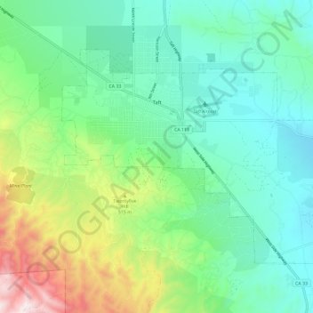
Name: Topografische Karte Taft, Höhe, Relief.
Ort: Taft, Kern County, California, 93268, United States (35.09343 -119.49192 35.15854 -119.37571)
Durchschnittliche Höhe: 370 m
Minimale Höhe: 181 m
Maximale Höhe: 878 m
Spenden
Rüste dich für dein nächstes Abenteuer:
Als Amazon-Partner verdient diese Seite an qualifizierten Käufen, ohne dass Ihnen zusätzliche Kosten entstehen.
Andere topografische Karten
Klicken Sie auf eine Karte, um ihre Topografie, ihre Höhe und ihr Relief anzuzeigen.
Lebec
United States > California > Kern County
According to the United States Census Bureau, Lebec has an area of 15.3 square miles (40 km2). The community, which is near Tejon Pass, lies at an elevation of 3,481 feet (1,061 m).
Durchschnittliche Höhe: 1’162 m
Frazier Park
United States > California > Kern County
Frazier Park is an unincorporated community in Kern County, California. It is 5 miles (8 km) west of Lebec, at an elevation of 4,639 feet (1,414 m). It is one of the Mountain Communities of the Tejon Pass. The population was 2,691 in the 2010 census, up from 2,348 in 2000.
Durchschnittliche Höhe: 1’533 m
Hart Memorial Park
United States > California > Kern County > Bakersfield
Durchschnittliche Höhe: 186 m
Spenden
Rüste dich für dein nächstes Abenteuer:
Als Amazon-Partner verdient diese Seite an qualifizierten Käufen, ohne dass Ihnen zusätzliche Kosten entstehen.
Pine Mountain Club
United States > California > Kern County
Pine Mountain Club has an area of 16.7 square miles (43.25 km2). It ranges from 4,901 to 6,400 feet (1,494 to 1,951 m) in elevation. The community sits in a deep valley of the San Emigdio Mountains, on the San Andreas fault. It is surrounded by Los Padres National Forest. The settlement lies between Apache…
Durchschnittliche Höhe: 1’867 m
Spenden
Rüste dich für dein nächstes Abenteuer:
Als Amazon-Partner verdient diese Seite an qualifizierten Käufen, ohne dass Ihnen zusätzliche Kosten entstehen.
Keene
United States > California > Kern County
Keene (formerly, Wells) is a census-designated place (CDP) in Kern County, California in the foothills of the Tehachapi Mountains at the southern extreme of the San Joaquin Valley. Keene is located 8.5 miles (14 km) northwest of Tehachapi, at an elevation of 2,602 feet (793 m). The population was 469 at the…
Durchschnittliche Höhe: 892 m
Onyx
United States > California > Kern County
Onyx (formerly, Scodie) is a census-designated place (CDP) in Kern County, California, United States. Onyx is located 3.5 miles (6 km) east-northeast of Weldon in the South Fork Valley at an elevation of 2,795 feet (852 m). The population was 457 at the 2020 census, down from 475 at the 2010 census.
Durchschnittliche Höhe: 1’205 m
Spenden
Rüste dich für dein nächstes Abenteuer:
Als Amazon-Partner verdient diese Seite an qualifizierten Käufen, ohne dass Ihnen zusätzliche Kosten entstehen.
Wofford Heights
United States > California > Kern County
Wofford Heights is a census-designated place (CDP) in the southern Sierra Nevada, in Kern County, California, United States. Wofford Heights is located in the west Kern River Valley, 3.5 miles (5.6 km) south-southwest of Kernville, at an elevation of 2,684 feet (818 m). The population was 2,200 at the 2010…
Durchschnittliche Höhe: 1’114 m
Frazier Park
United States > California > Kern County
Frazier Park is an unincorporated community and census-designated place in Kern County, California. It is 5 miles (8 km) west of Lebec, at an elevation of 4,639 feet (1,414 m). It is one of the Mountain Communities of the Tejon Pass. The population was 2,592 in the 2020 census, down from 2,691 in 2010.
Durchschnittliche Höhe: 1’533 m
Spenden
Rüste dich für dein nächstes Abenteuer:
Als Amazon-Partner verdient diese Seite an qualifizierten Käufen, ohne dass Ihnen zusätzliche Kosten entstehen.
Pine Mountain Club
United States > California > Kern County
Pine Mountain Club has an area of 16.7 square miles (43.25 km2). It ranges from 4,901 to 6,400 feet (1,494 to 1,951 m) in elevation. The community sits in a deep valley of the San Emigdio Mountains, on the San Andreas fault. It is surrounded by Los Padres National Forest. The settlement lies between Apache…
Durchschnittliche Höhe: 1’867 m
Lost Hills
United States > California > Kern County
Lost Hills (formerly, Lost Hill) is a census-designated place (CDP) in Kern County, California, United States. Lost Hills is located 42 miles (68 km) west-northwest of Bakersfield, at an elevation of 305 feet (93 m). The population was 2,412 at the 2010 census, up from 1,938 at the 2000 census.
Durchschnittliche Höhe: 82 m
Spenden
Rüste dich für dein nächstes Abenteuer:
Als Amazon-Partner verdient diese Seite an qualifizierten Käufen, ohne dass Ihnen zusätzliche Kosten entstehen.
Alta Sierra
United States > California > Kern County
Alta Sierra was laid out by property developers in the 1960s. Alta Sierra is a golf course community, with homes built around the Alta Sierra Country Club, a semi-private 18 hole course built in 1964. The community has a member-owned airport with a 2800-foot runway. The community is located just east of…
Durchschnittliche Höhe: 1’828 m
Mettler
United States > California > Kern County > Mettler
Mettler is 25 miles (40 km) south of Bakersfield.[1] The locality has an area of 0.2 square miles (0.52 km2) and an elevation of 541 feet (165 m).
Durchschnittliche Höhe: 164 m
Spenden
Rüste dich für dein nächstes Abenteuer:
Als Amazon-Partner verdient diese Seite an qualifizierten Käufen, ohne dass Ihnen zusätzliche Kosten entstehen.
Woodford
United States > California > Kern County
Keene (formerly, Wells) is a census-designated place (CDP) in Kern County, California in the foothills of the Tehachapi Mountains at the southern extreme of the San Joaquin Valley. Keene is located 8.5 miles (14 km) northwest of Tehachapi, at an elevation of 2,602 feet (793 m). The population was 469 at the…
Durchschnittliche Höhe: 899 m
Spenden
Rüste dich für dein nächstes Abenteuer:
Als Amazon-Partner verdient diese Seite an qualifizierten Käufen, ohne dass Ihnen zusätzliche Kosten entstehen.
Spenden
Rüste dich für dein nächstes Abenteuer:
Als Amazon-Partner verdient diese Seite an qualifizierten Käufen, ohne dass Ihnen zusätzliche Kosten entstehen.
Miracle Hot Springs
United States > California > Kern County > Bodfish > Miracle Hot Springs
Durchschnittliche Höhe: 859 m
Spenden
Rüste dich für dein nächstes Abenteuer:
Als Amazon-Partner verdient diese Seite an qualifizierten Käufen, ohne dass Ihnen zusätzliche Kosten entstehen.
Spenden
Rüste dich für dein nächstes Abenteuer:
Als Amazon-Partner verdient diese Seite an qualifizierten Käufen, ohne dass Ihnen zusätzliche Kosten entstehen.
Frazier Park
United States > California > Kern County
Frazier Park is a village and unincorporated community in Kern County, California. It is 5 miles (8 km) west of Lebec, at an elevation of 4,639 feet (1,414 m). It is one of the Mountain Communities of the Tejon Pass. The population was 2,592 in the 2020 census, down from 2,691 in 2010.
Durchschnittliche Höhe: 1’533 m
Spenden
Rüste dich für dein nächstes Abenteuer:
Als Amazon-Partner verdient diese Seite an qualifizierten Käufen, ohne dass Ihnen zusätzliche Kosten entstehen.
Onyx
United States > California > Kern County
Onyx (formerly, Scodie) is a census-designated place (CDP) in Kern County, California, United States. Onyx is located 3.5 miles (6 km) east-northeast of Weldon in the South Fork Valley at an elevation of 2,795 feet (852 m). The population was 475 at the 2010 census, down from 476 at the 2000 census.
Durchschnittliche Höhe: 1’205 m
Spenden
Rüste dich für dein nächstes Abenteuer:
Als Amazon-Partner verdient diese Seite an qualifizierten Käufen, ohne dass Ihnen zusätzliche Kosten entstehen.
McKittrick
United States > California > Kern County
McKittrick is a census-designated place (CDP) in Kern County, California, United States. McKittrick is located 14 miles (23 km) northwest of Taft, at an elevation of 1,056 feet (322 m). The population was 115 at the 2010 census, down from 160 at the 2000 census.
Durchschnittliche Höhe: 388 m
Spenden
Rüste dich für dein nächstes Abenteuer:
Als Amazon-Partner verdient diese Seite an qualifizierten Käufen, ohne dass Ihnen zusätzliche Kosten entstehen.