
Topografische Karte Teniente Hugo Ortiz
Interaktive Karte
Klicken Sie auf die Karte, um die Höhe anzuzeigen.
Über diese Karte
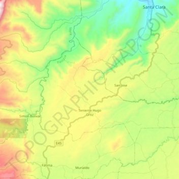
Name: Topografische Karte Teniente Hugo Ortiz, Höhe, Relief.
Ort: Teniente Hugo Ortiz, Pastaza, Ecuador (-1.40561 -78.00628 -1.29385 -77.81990)
Durchschnittliche Höhe: 975 m
Minimale Höhe: 557 m
Maximale Höhe: 1’627 m
Andere topografische Karten
Klicken Sie auf eine Karte, um ihre Topografie, ihre Höhe und ihr Relief anzuzeigen.
Las Americas
Ecuador > Pastaza > Pastaza > Puyo
Las Americas, Puyo, Pastaza, 160150, Ecuador
Durchschnittliche Höhe: 969 m
Pindo Chico
Ecuador > Pastaza > Pastaza > Puyo
Pindo Chico, Puyo, Pastaza, 160104, Ecuador
Durchschnittliche Höhe: 927 m
Diez de Agosto
Diez de Agosto, Pastaza, Ecuador
Durchschnittliche Höhe: 954 m
Veracruz (Indillama) (Cab. en Indillama)
Veracruz (Indillama) (Cab. en Indillama), Pastaza, Ecuador
Durchschnittliche Höhe: 855 m
Simon Bolivar
Simon Bolivar, Pastaza, Ecuador
Durchschnittliche Höhe: 692 m
Montalvo (Andoas)
Montalvo (Andoas), Pastaza, Ecuador
Durchschnittliche Höhe: 317 m