
Topografische Karte Apache
Interaktive Karte
Klicken Sie auf die Karte, um die Höhe anzuzeigen.
Über diese Karte
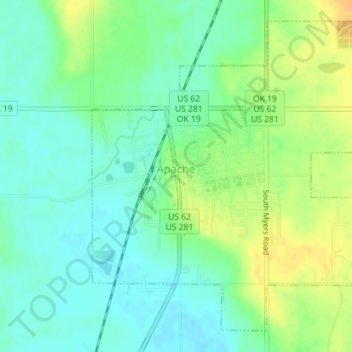
Name: Topografische Karte Apache, Höhe, Relief.
Ort: Apache, Caddo County, Oklahoma, United States (34.88028 -98.37437 34.90589 -98.33898)
Durchschnittliche Höhe: 390 m
Minimale Höhe: 378 m
Maximale Höhe: 408 m
Andere topografische Karten
Klicken Sie auf eine Karte, um ihre Topografie, ihre Höhe und ihr Relief anzuzeigen.
Bridgeport
United States > Oklahoma > Caddo County
Bridgeport, Caddo County, Oklahoma, United States
Durchschnittliche Höhe: 444 m
Boone
United States > Oklahoma > Caddo County
Boone, Caddo County, Oklahoma, United States
Durchschnittliche Höhe: 426 m
Carnegie
United States > Oklahoma > Caddo County
Carnegie, Caddo County, Oklahoma, 73015, United States
Durchschnittliche Höhe: 410 m
Scott
United States > Oklahoma > Caddo County
Scott, Caddo County, Oklahoma, United States
Durchschnittliche Höhe: 483 m
Anadarko
United States > Oklahoma > Caddo County
Anadarko, Caddo County, Oklahoma, 73005, United States
Durchschnittliche Höhe: 369 m
Washita
United States > Oklahoma > Caddo County > Washita
Washita, Caddo County, Oklahoma, United States
Durchschnittliche Höhe: 382 m
Hinton
United States > Oklahoma > Caddo County
Hinton, Caddo County, Oklahoma, United States
Durchschnittliche Höhe: 482 m