
Topografische Karte Conrad
Interaktive Karte
Klicken Sie auf die Karte, um die Höhe anzuzeigen.
Über diese Karte
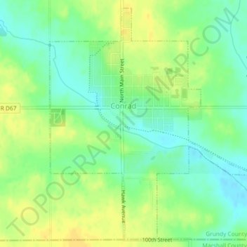
Name: Topografische Karte Conrad, Höhe, Relief.
Ort: Conrad, Grundy County, Iowa, 50621, United States (42.21006 -92.88518 42.23538 -92.85493)
Durchschnittliche Höhe: 313 m
Minimale Höhe: 300 m
Maximale Höhe: 325 m
Andere topografische Karten
Klicken Sie auf eine Karte, um ihre Topografie, ihre Höhe und ihr Relief anzuzeigen.
Grundy Center
United States > Iowa > Grundy County
Grundy Center, Grundy County, Iowa, United States
Durchschnittliche Höhe: 306 m
Dike
United States > Iowa > Grundy County
Dike, Grundy County, Iowa, United States
Durchschnittliche Höhe: 291 m
Beaman
United States > Iowa > Grundy County
Beaman, Grundy County, Iowa, United States
Durchschnittliche Höhe: 309 m
Wellsburg
United States > Iowa > Grundy County
Wellsburg, Grundy County, Iowa, United States
Durchschnittliche Höhe: 327 m
Holland
United States > Iowa > Grundy County
Holland, Grundy County, Iowa, United States
Durchschnittliche Höhe: 310 m
Reinbeck
United States > Iowa > Grundy County
Reinbeck, Grundy County, Iowa, 50669, United States
Durchschnittliche Höhe: 290 m
Stout
United States > Iowa > Grundy County
Stout, Grundy County, Iowa, 50673, United States
Durchschnittliche Höhe: 309 m
Morrison
United States > Iowa > Grundy County
Morrison, Grundy County, Iowa, 50657, United States
Durchschnittliche Höhe: 295 m