
Topografische Karte Gallatin National Forest
Interaktive Karte
Klicken Sie auf die Karte, um die Höhe anzuzeigen.
Über diese Karte
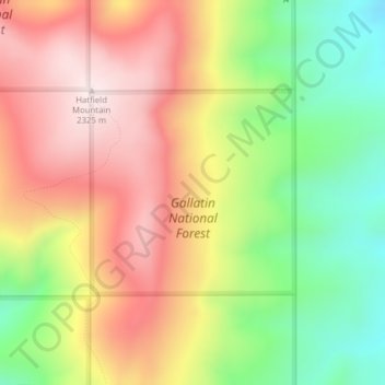
Name: Topografische Karte Gallatin National Forest, Höhe, Relief.
Durchschnittliche Höhe: 2’064 m
Minimale Höhe: 1’785 m
Maximale Höhe: 2’326 m
Andere topografische Karten
Klicken Sie auf eine Karte, um ihre Topografie, ihre Höhe und ihr Relief anzuzeigen.
Bozeman
United States > Montana > Gallatin County
Bozeman, Gallatin County, Montana, United States
Durchschnittliche Höhe: 1’495 m
West Yellowstone
United States > Montana > Gallatin County
West Yellowstone, Gallatin County, Montana, United States
Durchschnittliche Höhe: 2’034 m
Big Sky
United States > Montana > Gallatin County
Big Sky, Gallatin County, Montana, United States
Durchschnittliche Höhe: 2’435 m
Logan
United States > Montana > Gallatin County
Logan, Gallatin County, Montana, United States
Durchschnittliche Höhe: 1’294 m
Clarkston
United States > Montana > Gallatin County
Clarkston, Gallatin County, Montana, United States
Durchschnittliche Höhe: 1’236 m
Gallatin River
United States > Montana > Gallatin County
Gallatin River, Gallatin Gateway, Gallatin County, Montana, United States
Durchschnittliche Höhe: 1’509 m
Manhattan
United States > Montana > Gallatin County
Manhattan, Gallatin County, Montana, United States
Durchschnittliche Höhe: 1’294 m
Three Forks
United States > Montana > Gallatin County
Three Forks, Gallatin County, Montana, United States
Durchschnittliche Höhe: 1’249 m
Four Corners
United States > Montana > Gallatin County
Four Corners, Gallatin County, Montana, United States
Durchschnittliche Höhe: 1’469 m
Bozeman
United States > Montana > Gallatin County > Bozeman
Bozeman, Gallatin County, Montana, 59715, United States
Durchschnittliche Höhe: 1’679 m
Big Sky Canyon Village
United States > Montana > Gallatin County > Big Sky Canyon Village
Big Sky Canyon Village, Gallatin County, Montana, United States
Durchschnittliche Höhe: 1’994 m
Belgrade
United States > Montana > Gallatin County
Belgrade, Gallatin County, Montana, 59714, United States
Durchschnittliche Höhe: 1’355 m