
Spenden
Rüste dich für dein nächstes Abenteuer:
Als Amazon-Partner verdient diese Seite an qualifizierten Käufen, ohne dass Ihnen zusätzliche Kosten entstehen.
Topografische Karte Mount Olive
Klicken Sie auf die Karte, um die Höhe anzuzeigen.
Spenden
Rüste dich für dein nächstes Abenteuer:
Als Amazon-Partner verdient diese Seite an qualifizierten Käufen, ohne dass Ihnen zusätzliche Kosten entstehen.
Über diese Karte
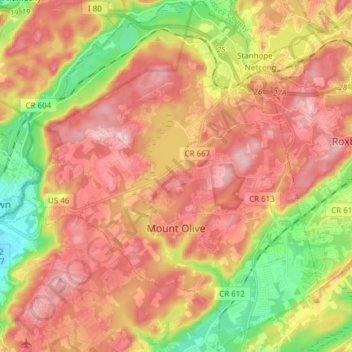
Name: Topografische Karte Mount Olive, Höhe, Relief.
Ort: Mount Olive, Morris County, New Jersey, United States (40.80552 -74.82171 40.92084 -74.68118)
Durchschnittliche Höhe: 280 m
Minimale Höhe: 154 m
Maximale Höhe: 380 m
Spenden
Rüste dich für dein nächstes Abenteuer:
Als Amazon-Partner verdient diese Seite an qualifizierten Käufen, ohne dass Ihnen zusätzliche Kosten entstehen.
Andere topografische Karten
Klicken Sie auf eine Karte, um ihre Topografie, ihre Höhe und ihr Relief anzuzeigen.
Kenvil
United States > New Jersey > Morris County > Roxbury Township > Succasunna
Durchschnittliche Höhe: 239 m
Washington Valley
United States > New Jersey > Morris County > Morris Township
Durchschnittliche Höhe: 152 m
Birch Hills
United States > New Jersey > Morris County > Hanover Township
Durchschnittliche Höhe: 83 m
Spenden
Rüste dich für dein nächstes Abenteuer:
Als Amazon-Partner verdient diese Seite an qualifizierten Käufen, ohne dass Ihnen zusätzliche Kosten entstehen.
Shore Hills
United States > New Jersey > Morris County > Roxbury Township
Durchschnittliche Höhe: 298 m
Floral Hill
United States > New Jersey > Morris County > Chatham Township
Durchschnittliche Höhe: 90 m
Powder Mill Pond Dam
United States > New Jersey > Morris County > Parsippany-Troy Hills > Tabor
Durchschnittliche Höhe: 178 m
Spenden
Rüste dich für dein nächstes Abenteuer:
Als Amazon-Partner verdient diese Seite an qualifizierten Käufen, ohne dass Ihnen zusätzliche Kosten entstehen.
Parsippany
United States > New Jersey > Morris County > Parsippany-Troy Hills
Durchschnittliche Höhe: 95 m
Spenden
Rüste dich für dein nächstes Abenteuer:
Als Amazon-Partner verdient diese Seite an qualifizierten Käufen, ohne dass Ihnen zusätzliche Kosten entstehen.
Taylortown
United States > New Jersey > Morris County > Montville Township
Durchschnittliche Höhe: 190 m
Mooney Mountain Park
United States > New Jersey > Morris County > Roxbury Township
Durchschnittliche Höhe: 326 m
Spenden
Rüste dich für dein nächstes Abenteuer:
Als Amazon-Partner verdient diese Seite an qualifizierten Käufen, ohne dass Ihnen zusätzliche Kosten entstehen.
Schooleys Mountain
United States > New Jersey > Morris County > Washington Township
Durchschnittliche Höhe: 293 m
Meyersville
United States > New Jersey > Morris County > Long Hill Township
Durchschnittliche Höhe: 77 m
Spenden
Rüste dich für dein nächstes Abenteuer:
Als Amazon-Partner verdient diese Seite an qualifizierten Käufen, ohne dass Ihnen zusätzliche Kosten entstehen.
Lake Parsippany
United States > New Jersey > Morris County > Parsippany-Troy Hills
Durchschnittliche Höhe: 93 m
Pleasant Valley
United States > New Jersey > Morris County > Mendham Township
Durchschnittliche Höhe: 156 m
Mount Freedom
United States > New Jersey > Morris County > Randolph Township
Durchschnittliche Höhe: 269 m
Spenden
Rüste dich für dein nächstes Abenteuer:
Als Amazon-Partner verdient diese Seite an qualifizierten Käufen, ohne dass Ihnen zusätzliche Kosten entstehen.
Calais Crossroads
United States > New Jersey > Morris County > Randolph Township
Durchschnittliche Höhe: 284 m
Washington Corner
United States > New Jersey > Morris County > Mendham Township
Durchschnittliche Höhe: 174 m
Tabor
United States > New Jersey > Morris County > Parsippany-Troy Hills
Durchschnittliche Höhe: 180 m
Spenden
Rüste dich für dein nächstes Abenteuer:
Als Amazon-Partner verdient diese Seite an qualifizierten Käufen, ohne dass Ihnen zusätzliche Kosten entstehen.
Pine Brook
United States > New Jersey > Morris County > Montville Township
Durchschnittliche Höhe: 56 m
Spenden
Rüste dich für dein nächstes Abenteuer:
Als Amazon-Partner verdient diese Seite an qualifizierten Käufen, ohne dass Ihnen zusätzliche Kosten entstehen.
Lower Montville
United States > New Jersey > Morris County > Montville Township
Durchschnittliche Höhe: 84 m
Mount Fern
United States > New Jersey > Morris County > Randolph Township
Durchschnittliche Höhe: 265 m
Parsippany
United States > New Jersey > Morris County > Parsippany-Troy Hills
Durchschnittliche Höhe: 95 m
Spenden
Rüste dich für dein nächstes Abenteuer:
Als Amazon-Partner verdient diese Seite an qualifizierten Käufen, ohne dass Ihnen zusätzliche Kosten entstehen.
Lake Hiawatha
United States > New Jersey > Morris County > Parsippany-Troy Hills
Durchschnittliche Höhe: 76 m
Beach Glen
United States > New Jersey > Morris County > Rockaway Township > Beach Glen
Durchschnittliche Höhe: 209 m
Crestview
United States > New Jersey > Morris County > Madison > Crestview
Durchschnittliche Höhe: 87 m
Spenden
Rüste dich für dein nächstes Abenteuer:
Als Amazon-Partner verdient diese Seite an qualifizierten Käufen, ohne dass Ihnen zusätzliche Kosten entstehen.
Floral Hill
United States > New Jersey > Morris County > Chatham Township > Floral Hill
Durchschnittliche Höhe: 90 m
Petersburg
United States > New Jersey > Morris County > Jefferson Township
Durchschnittliche Höhe: 297 m
Rockaway Valley
United States > New Jersey > Morris County > Boonton Township
Durchschnittliche Höhe: 181 m
Spenden
Rüste dich für dein nächstes Abenteuer:
Als Amazon-Partner verdient diese Seite an qualifizierten Käufen, ohne dass Ihnen zusätzliche Kosten entstehen.
New Vernon
United States > New Jersey > Morris County > Harding Township
Durchschnittliche Höhe: 104 m
Roxbury Township
United States > New Jersey > Morris County > Roxbury Township
Durchschnittliche Höhe: 264 m
Rolling Hill
United States > New Jersey > Morris County > Chatham Township
Durchschnittliche Höhe: 89 m