
Topografische Karte Rome
Interaktive Karte
Klicken Sie auf die Karte, um die Höhe anzuzeigen.
Über diese Karte
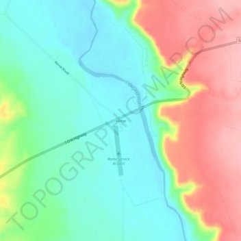
Name: Topografische Karte Rome, Höhe, Relief.
Ort: Rome, Malheur County, Oregon, United States (42.81830 -117.64852 42.85830 -117.60852)
Durchschnittliche Höhe: 1’075 m
Minimale Höhe: 1’022 m
Maximale Höhe: 1’161 m
Andere topografische Karten
Klicken Sie auf eine Karte, um ihre Topografie, ihre Höhe und ihr Relief anzuzeigen.
Owyhee River
United States > Oregon > Malheur County
Owyhee River, Malheur County, Oregon, United States
Durchschnittliche Höhe: 670 m
Beulah
United States > Oregon > Malheur County
Beulah, Malheur County, Oregon, United States
Durchschnittliche Höhe: 1’121 m
Snake River
United States > Oregon > Malheur County > Nyssa
Snake River, Nyssa, Malheur County, Oregon, United States
Durchschnittliche Höhe: 669 m
Jordan Valley
United States > Oregon > Malheur County
Jordan Valley, Malheur County, Oregon, 97910, United States
Durchschnittliche Höhe: 1’354 m
Cairo
United States > Oregon > Malheur County
Cairo, Malheur County, Oregon, United States
Durchschnittliche Höhe: 669 m
Vale
United States > Oregon > Malheur County
Vale, Malheur County, Oregon, United States
Durchschnittliche Höhe: 710 m
Harper
United States > Oregon > Malheur County
Harper, Malheur County, Oregon, 97906, United States
Durchschnittliche Höhe: 781 m
Nyssa
United States > Oregon > Malheur County
Nyssa, Malheur County, Oregon, 97913, United States
Durchschnittliche Höhe: 667 m
Ontario
United States > Oregon > Malheur County
Ontario, Malheur County, Oregon, 97914, United States
Durchschnittliche Höhe: 660 m