
Topografische Karte Barnett Springs
Interaktive Karte
Klicken Sie auf die Karte, um die Höhe anzuzeigen.
Über diese Karte
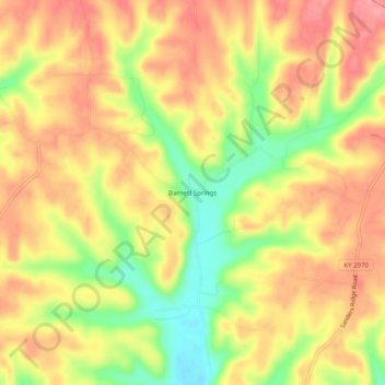
Name: Topografische Karte Barnett Springs, Höhe, Relief.
Ort: Barnett Springs, Adair County, Kentucky, United States (37.22201 -85.11135 37.26201 -85.07135)
Durchschnittliche Höhe: 285 m
Minimale Höhe: 226 m
Maximale Höhe: 325 m
Andere topografische Karten
Klicken Sie auf eine Karte, um ihre Topografie, ihre Höhe und ihr Relief anzuzeigen.
Cane Valley
United States > Kentucky > Adair County
Cane Valley, Adair County, Kentucky, United States
Durchschnittliche Höhe: 255 m
Flatwood
United States > Kentucky > Adair County
Flatwood, Adair County, Kentucky, United States
Durchschnittliche Höhe: 252 m
Columbia
United States > Kentucky > Adair County
Columbia, Adair County, Kentucky, 42728, United States
Durchschnittliche Höhe: 241 m
Pickett
United States > Kentucky > Adair County > Pickett
Pickett, Adair County, Kentucky, 42742, United States
Durchschnittliche Höhe: 224 m
Chance
United States > Kentucky > Adair County > Chance
Chance, Adair County, Kentucky, United States
Durchschnittliche Höhe: 276 m
Breeding
United States > Kentucky > Adair County
Breeding, Adair County, Kentucky, United States
Durchschnittliche Höhe: 302 m