
Spenden
Rüste dich für dein nächstes Abenteuer:
Als Amazon-Partner verdient diese Seite an qualifizierten Käufen, ohne dass Ihnen zusätzliche Kosten entstehen.
Topografische Karte Wausau
Klicken Sie auf die Karte, um die Höhe anzuzeigen.
Spenden
Rüste dich für dein nächstes Abenteuer:
Als Amazon-Partner verdient diese Seite an qualifizierten Käufen, ohne dass Ihnen zusätzliche Kosten entstehen.
Wausau
According to the United States Census Bureau, the city has a total area of 20.33 square miles (52.7 km2), of which 19.22 square miles (49.8 km2) is land and 1.11 square miles (2.9 km2) is water. The city is located at an altitude of 1,195 feet (364 m). Wausau is close to the center of the northern half of the Western Hemisphere. Just west of Wausau, 45°N meets 90°W (45°N 90°W / 45°N 90°W / 45; -90), which is exactly halfway between the equator and the north pole and a quarter of the way around the world from the prime meridian.
Spenden
Rüste dich für dein nächstes Abenteuer:
Als Amazon-Partner verdient diese Seite an qualifizierten Käufen, ohne dass Ihnen zusätzliche Kosten entstehen.
Über diese Karte
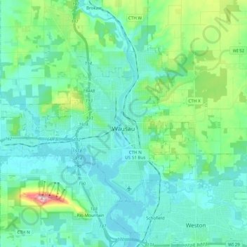
Name: Topografische Karte Wausau, Höhe, Relief.
Ort: Wausau, Marathon County, Wisconsin, United States (44.91855 -89.76793 45.00644 -89.57292)
Durchschnittliche Höhe: 394 m
Minimale Höhe: 351 m
Maximale Höhe: 585 m
Spenden
Rüste dich für dein nächstes Abenteuer:
Als Amazon-Partner verdient diese Seite an qualifizierten Käufen, ohne dass Ihnen zusätzliche Kosten entstehen.
Andere topografische Karten
Klicken Sie auf eine Karte, um ihre Topografie, ihre Höhe und ihr Relief anzuzeigen.
Rib Mountain State Park
United States > Wisconsin > Marathon County > Wausau
Durchschnittliche Höhe: 406 m
George W Mead State Wildlife Management Area
United States > Wisconsin > Marathon County > Town of Bergen
Durchschnittliche Höhe: 343 m
Rib Mountain State Park
United States > Wisconsin > Marathon County > Wausau
Durchschnittliche Höhe: 406 m
Spenden
Rüste dich für dein nächstes Abenteuer:
Als Amazon-Partner verdient diese Seite an qualifizierten Käufen, ohne dass Ihnen zusätzliche Kosten entstehen.
Bypass Channel Wisconsin River
United States > Wisconsin > Marathon County > Wausau
Durchschnittliche Höhe: 371 m