
Topografische Karte Oneida
Interaktive Karte
Klicken Sie auf die Karte, um die Höhe anzuzeigen.
Über diese Karte
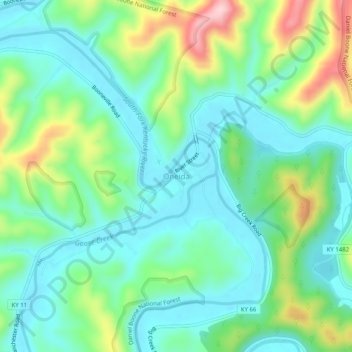
Name: Topografische Karte Oneida, Höhe, Relief.
Ort: Oneida, Clay County, Kentucky, United States (37.24953 -83.66908 37.28953 -83.62908)
Durchschnittliche Höhe: 297 m
Minimale Höhe: 227 m
Maximale Höhe: 477 m
Andere topografische Karten
Klicken Sie auf eine Karte, um ihre Topografie, ihre Höhe und ihr Relief anzuzeigen.
Littleton
United States > Kentucky > Clay County
Littleton, Clay County, Kentucky, 40962, United States
Durchschnittliche Höhe: 315 m
Sextons Creek
United States > Kentucky > Clay County
Sextons Creek, Clay County, Kentucky, 40983, United States
Durchschnittliche Höhe: 311 m
Big Creek
United States > Kentucky > Clay County
Big Creek, Clay County, Kentucky, 40914, United States
Durchschnittliche Höhe: 354 m
Fall Rock
United States > Kentucky > Clay County
Fall Rock, Clay County, Kentucky, United States
Durchschnittliche Höhe: 344 m
Manchester
United States > Kentucky > Clay County
Manchester, Clay County, Kentucky, 40962, United States
Durchschnittliche Höhe: 315 m
Vine
United States > Kentucky > Clay County
Vine, Clay County, Kentucky, United States
Durchschnittliche Höhe: 335 m