
Topografische Karte Sims
Interaktive Karte
Klicken Sie auf die Karte, um die Höhe anzuzeigen.
Über diese Karte
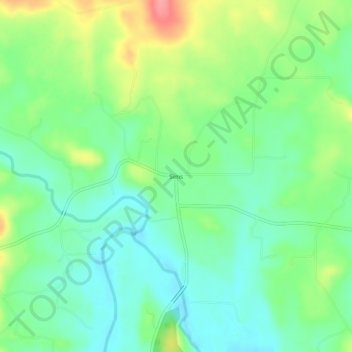
Name: Topografische Karte Sims, Höhe, Relief.
Ort: Sims, Montgomery County, Arkansas, 71969, United States (34.63926 -93.71103 34.67926 -93.67103)
Durchschnittliche Höhe: 227 m
Minimale Höhe: 197 m
Maximale Höhe: 285 m
Andere topografische Karten
Klicken Sie auf eine Karte, um ihre Topografie, ihre Höhe und ihr Relief anzuzeigen.
Joplin
United States > Arkansas > Montgomery County
Joplin, Montgomery County, Arkansas, United States
Durchschnittliche Höhe: 231 m
Ophir
United States > Arkansas > Montgomery County
Ophir, Montgomery County, Arkansas, United States
Durchschnittliche Höhe: 238 m
Mount Ida
United States > Arkansas > Montgomery County
Mount Ida, Montgomery County, Arkansas, United States
Durchschnittliche Höhe: 215 m
Norman
United States > Arkansas > Montgomery County
Norman, Montgomery County, Arkansas, 71960, United States
Durchschnittliche Höhe: 227 m
Mount Ida
United States > Arkansas > Montgomery County > Mount Ida
Mount Ida, Montgomery County, Arkansas, United States
Durchschnittliche Höhe: 215 m
Mount Ida
United States > Arkansas > Montgomery County > Mount Ida > Mount Ida
Mount Ida, Montgomery County, Arkansas, United States
Durchschnittliche Höhe: 216 m