
Topografische Karte Flour Lake
Interaktive Karte
Klicken Sie auf die Karte, um die Höhe anzuzeigen.
Über diese Karte
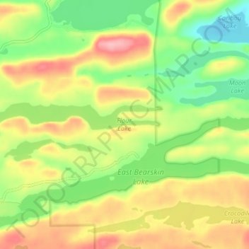
Name: Topografische Karte Flour Lake, Höhe, Relief.
Ort: Flour Lake, Cook County, Minnesota, United States (48.04808 -90.41848 48.05570 -90.35357)
Durchschnittliche Höhe: 535 m
Minimale Höhe: 479 m
Maximale Höhe: 599 m
Andere topografische Karten
Klicken Sie auf eine Karte, um ihre Topografie, ihre Höhe und ihr Relief anzuzeigen.
Schroeder
United States > Minnesota > Cook County
Schroeder, Schroeder Township, Cook County, Minnesota, United States
Durchschnittliche Höhe: 235 m
Grand Marais
United States > Minnesota > Cook County
Grand Marais, Cook County, Minnesota, United States
Durchschnittliche Höhe: 280 m
Magic Lake
United States > Minnesota > Cook County
Magic Lake, Schroeder Township, Cook County, Minnesota, United States
Durchschnittliche Höhe: 564 m
Ptarmigan Lake
United States > Minnesota > Cook County
Ptarmigan Lake, West Cook, Cook County, Minnesota, United States
Durchschnittliche Höhe: 612 m
Lutsen
United States > Minnesota > Cook County
Lutsen, Lutsen Township, Cook County, Minnesota, 55612, United States
Durchschnittliche Höhe: 225 m
Cherokee Lake
United States > Minnesota > Cook County
Cherokee Lake, Cook County, Minnesota, United States
Durchschnittliche Höhe: 565 m
Olso Lake
United States > Minnesota > Cook County
Olso Lake, Cook County, Minnesota, United States
Durchschnittliche Höhe: 544 m
Hovland
United States > Minnesota > Cook County
Hovland, East Cook, Cook County, Minnesota, 56606, United States
Durchschnittliche Höhe: 226 m
Ball Club Lake
United States > Minnesota > Cook County
Ball Club Lake, Cook County, Minnesota, United States
Durchschnittliche Höhe: 610 m
Tofte
United States > Minnesota > Cook County
Tofte, Tofte Township, Cook County, Minnesota, 55613, United States
Durchschnittliche Höhe: 223 m
Grand Portage
United States > Minnesota > Cook County
Grand Portage, Cook County, Minnesota, 55605, United States
Durchschnittliche Höhe: 257 m
Grand Portage National Monument
United States > Minnesota > Cook County
Grand Portage National Monument, Cook County, Minnesota, 55605, United States
Durchschnittliche Höhe: 314 m
Eagle Mountain
United States > Minnesota > Cook County
Eagle Mountain, Cook County, Minnesota, United States
Durchschnittliche Höhe: 596 m
Chippewa City
United States > Minnesota > Cook County > Chippewa City
Chippewa City, Cook County, Minnesota, United States
Durchschnittliche Höhe: 238 m
Potato Lake
United States > Minnesota > Cook County
Potato Lake, East Cook, Cook County, Minnesota, United States
Durchschnittliche Höhe: 621 m