
Topografische Karte Warsaw
Interaktive Karte
Klicken Sie auf die Karte, um die Höhe anzuzeigen.
Über diese Karte
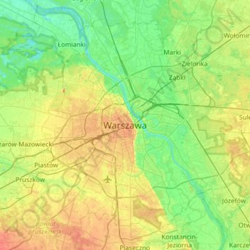
Name: Topografische Karte Warsaw, Höhe, Relief.
Ort: Warsaw, Masovian Voivodeship, 00-901, Poland (52.07196 20.84672 52.39196 21.16672)
Durchschnittliche Höhe: 95 m
Minimale Höhe: 71 m
Maximale Höhe: 146 m
Warsaw lies in east-central Poland about 300 km (190 mi) from the Carpathian Mountains and about 260 km (160 mi) from the Baltic Sea, 523 km (325 mi) east of Berlin, Germany. The city straddles the Vistula River. It is located in the heartland of the Masovian Plain, and its average elevation is 100 m (330 ft) above sea level. The highest point on the left side of the city lies at a height of 115.7 m (380 ft) ("Redutowa" bus depot, district of Wola), on the right side – 122.1 m (401 ft) ("Groszówka" estate, district of Wesoła, by the eastern border). The lowest point lies at a height 75.6 m (248 ft) (at the right bank of the Vistula, by the eastern border of Warsaw). There are some hills (mostly artificial) located within the confines of the city – e.g. Warsaw Uprising Hill (121 m (397 ft)) and Szczęśliwice hill (138 m (453 ft) – the highest point of Warsaw in general).