Geolokalisieren

Topografische Karte Gillingham

Klicken Sie auf die Karte, um die Höhe anzuzeigen.

Über diese Karte

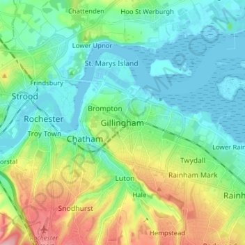
Name: Topografische Karte Gillingham, Höhe, Relief.

Ort: Gillingham, Kent, England, ME7 5FA, United Kingdom (51.34717 0.50616 51.42717 0.58616)

Durchschnittliche Höhe: 40 m

Minimale Höhe: -2 m

Maximale Höhe: 146 m

Andere topografische Karten

Klicken Sie auf eine Karte, um ihre Topografie, ihre Höhe und ihr Relief anzuzeigen.

Whitstable

United Kingdom > England > Kent

Durchschnittliche Höhe: 15 m

Dartford

United Kingdom > England > Kent

Durchschnittliche Höhe: 40 m

Canterbury

United Kingdom > England > Kent

Durchschnittliche Höhe: 51 m

Rochester

United Kingdom > England > Kent

Durchschnittliche Höhe: 51 m

Maidstone

United Kingdom > England > Kent

Durchschnittliche Höhe: 70 m

Thanet

United Kingdom > England > Kent

Durchschnittliche Höhe: 10 m

Ash

United Kingdom > England > Kent > Dover

Durchschnittliche Höhe: 9 m

Capel-le-Ferne

United Kingdom > England > Kent > Dover

Durchschnittliche Höhe: 124 m

Lyminge

United Kingdom > England > Kent > Folkestone and Hythe District

Durchschnittliche Höhe: 139 m

Gravesham

United Kingdom > England > Kent

Durchschnittliche Höhe: 63 m

Ashford

United Kingdom > England > Kent

Durchschnittliche Höhe: 60 m

Dover

United Kingdom > England > Kent

Durchschnittliche Höhe: 39 m

Boughton Malherbe

United Kingdom > England > Kent > Maidstone

Durchschnittliche Höhe: 75 m

Frittenden

United Kingdom > England > Kent > Tunbridge Wells

Durchschnittliche Höhe: 34 m

Boughton under Blean

United Kingdom > England > Kent > Borough of Swale

Durchschnittliche Höhe: 48 m

Shorne Wood

United Kingdom > England > Kent > Gravesham > Shorne Ridgeway

Durchschnittliche Höhe: 83 m

Gravesend

United Kingdom > England > Kent > Gravesham

Durchschnittliche Höhe: 31 m

Robins Creek

United Kingdom > England > Kent > Gravesham > Northfleet

Durchschnittliche Höhe: 10 m

Margate

United Kingdom > England > Kent > Thanet

Durchschnittliche Höhe: 22 m

Eynsford

United Kingdom > England > Kent > Sevenoaks > Eynsford

Durchschnittliche Höhe: 104 m

Herne Bay

United Kingdom > England > Kent

Durchschnittliche Höhe: 17 m

Kemsing

United Kingdom > England > Kent > Sevenoaks

Durchschnittliche Höhe: 139 m

Boughton Aluph

United Kingdom > England > Kent > Ashford > Boughton Lees

Durchschnittliche Höhe: 78 m

Isle of Sheppey

United Kingdom > England > Kent > Borough of Swale

Durchschnittliche Höhe: 6 m

River Medway

United Kingdom > England > Kent

Durchschnittliche Höhe: 68 m

Darent

United Kingdom > England > Kent > Sevenoaks

Durchschnittliche Höhe: 92 m

Tonbridge and Malling

United Kingdom > England > Kent

Durchschnittliche Höhe: 77 m

Shadoxhurst

United Kingdom > England > Kent > Ashford > Shadoxhurst

Durchschnittliche Höhe: 43 m

Sevenoaks

United Kingdom > England > Kent > Sevenoaks

Durchschnittliche Höhe: 127 m

Kent Downs National Landscape

United Kingdom > England > Kent

Durchschnittliche Höhe: 25 m

Sandgate

United Kingdom > England > Kent > Folkestone and Hythe District

Durchschnittliche Höhe: 34 m

Vielen Dank für die Unterstützung dieser Website ❤️
Spenden

Rüste dich für dein nächstes Abenteuer:

Als Amazon-Partner verdient diese Seite an qualifizierten Käufen, ohne dass Ihnen zusätzliche Kosten entstehen.

Dover Castle

United Kingdom > England > Kent > Dover

Durchschnittliche Höhe: 47 m

Selling

United Kingdom > England > Kent > Borough of Swale

Durchschnittliche Höhe: 64 m

Luddesdown

United Kingdom > England > Kent > Gravesham

Durchschnittliche Höhe: 109 m

Newnham

United Kingdom > England > Kent > Borough of Swale > Newnham

Durchschnittliche Höhe: 89 m

Folkestone and Hythe District

United Kingdom > England > Kent

Durchschnittliche Höhe: 40 m

Lower Halstow

United Kingdom > England > Kent > Borough of Swale

Durchschnittliche Höhe: 12 m

Newington

United Kingdom > England > Kent > Borough of Swale

Durchschnittliche Höhe: 45 m

Bobbing

United Kingdom > England > Kent > Borough of Swale

Durchschnittliche Höhe: 32 m

Challock

United Kingdom > England > Kent > Ashford > Challock

Durchschnittliche Höhe: 136 m

Mote Park

United Kingdom > England > Kent > Maidstone > Otham

Durchschnittliche Höhe: 52 m

Borough of Swale

United Kingdom > England > Kent

Durchschnittliche Höhe: 50 m

Edenbridge

United Kingdom > England > Kent

Durchschnittliche Höhe: 67 m

Hoath

United Kingdom > England > Kent > Canterbury

Durchschnittliche Höhe: 24 m

Sandwich

United Kingdom > England > Kent

Durchschnittliche Höhe: 5 m

Penshurst

United Kingdom > England > Kent > Sevenoaks

Durchschnittliche Höhe: 66 m

Tenterden

United Kingdom > England > Kent > Tenterden

Durchschnittliche Höhe: 28 m

Sheerness

United Kingdom > England > Kent > Borough of Swale

Durchschnittliche Höhe: 3 m

Westerham

United Kingdom > England > Kent > Sevenoaks > Hosey Hill

Durchschnittliche Höhe: 134 m

Aylesford

United Kingdom > England > Kent > Tonbridge and Malling > Aylesford

Durchschnittliche Höhe: 60 m

Hythe

United Kingdom > England > Kent > Folkestone and Hythe District

Durchschnittliche Höhe: 32 m

Crockenhill

United Kingdom > England > Kent > Sevenoaks

Durchschnittliche Höhe: 96 m

Hawkinge

United Kingdom > England > Kent > Folkestone and Hythe District

Durchschnittliche Höhe: 140 m

Walmer

United Kingdom > England > Kent > Dover

Durchschnittliche Höhe: 12 m

Sturry

United Kingdom > England > Kent > Canterbury

Durchschnittliche Höhe: 32 m

Woodchurch

United Kingdom > England > Kent > Ashford > Woodchurch

Durchschnittliche Höhe: 28 m

Faversham

United Kingdom > England > Kent > Borough of Swale

Durchschnittliche Höhe: 17 m

Ramsgate

United Kingdom > England > Kent > Thanet

In 2017 Ramsgate was chosen as one of the first ten Heritage Action Zones (HAZ) by Historic England, with the aim of stimulating economic growth by taking advantage of Ramsgate's historic environment. Part of this project included a Historic Landscape Characterisation Study which assessed and mapped the…

Durchschnittliche Höhe: 25 m

Westgate-on-Sea

United Kingdom > England > Kent > Thanet

Durchschnittliche Höhe: 17 m

Wittersham

United Kingdom > England > Kent > Ashford

Durchschnittliche Höhe: 18 m

Plaxtol

United Kingdom > England > Kent > Tonbridge and Malling

Durchschnittliche Höhe: 100 m

Eastry

United Kingdom > England > Kent > Dover

Durchschnittliche Höhe: 32 m

Borough Green

United Kingdom > England > Kent > Tonbridge and Malling

Durchschnittliche Höhe: 96 m

West Malling

United Kingdom > England > Kent > Tonbridge and Malling

Durchschnittliche Höhe: 58 m

Hawkhurst

United Kingdom > England > Kent > Tunbridge Wells

Durchschnittliche Höhe: 67 m

Chart Sutton

United Kingdom > England > Kent > Maidstone

Durchschnittliche Höhe: 54 m

Biddenden

United Kingdom > England > Kent > Ashford

Durchschnittliche Höhe: 46 m

Paddock Wood

United Kingdom > England > Kent > Tunbridge Wells

Durchschnittliche Höhe: 33 m

Wateringbury

United Kingdom > England > Kent > Tonbridge and Malling

Durchschnittliche Höhe: 63 m

Meopham

United Kingdom > England > Kent > Gravesham

Durchschnittliche Höhe: 124 m

Charing

United Kingdom > England > Kent > Ashford

Durchschnittliche Höhe: 122 m

Whitfield

United Kingdom > England > Kent > Dover

Durchschnittliche Höhe: 101 m

Kings Hill

United Kingdom > England > Kent > Tonbridge and Malling > Kings Hill

Durchschnittliche Höhe: 82 m

Appledore

United Kingdom > England > Kent > Ashford

Durchschnittliche Höhe: 9 m

Boughton Monchelsea

United Kingdom > England > Kent > Maidstone

Durchschnittliche Höhe: 65 m

Temple Ewell

United Kingdom > England > Kent > Dover

Durchschnittliche Höhe: 96 m

Staplehurst

United Kingdom > England > Kent > Maidstone

Durchschnittliche Höhe: 26 m

Chartham

United Kingdom > England > Kent > Canterbury

Durchschnittliche Höhe: 60 m

Vielen Dank für die Unterstützung dieser Website ❤️
Spenden

Rüste dich für dein nächstes Abenteuer:

Als Amazon-Partner verdient diese Seite an qualifizierten Käufen, ohne dass Ihnen zusätzliche Kosten entstehen.

River

United Kingdom > England > Kent > Dover

Durchschnittliche Höhe: 80 m

Bredgar

United Kingdom > England > Kent > Borough of Swale

Durchschnittliche Höhe: 100 m

Chiddingstone

United Kingdom > England > Kent > Sevenoaks

Durchschnittliche Höhe: 64 m

Westbere

United Kingdom > England > Kent > Canterbury

Durchschnittliche Höhe: 21 m

Bidborough

United Kingdom > England > Kent > Tunbridge Wells

Durchschnittliche Höhe: 71 m

Wrotham

United Kingdom > England > Kent > Tonbridge and Malling > Wrotham

Durchschnittliche Höhe: 145 m

Repton

United Kingdom > England > Kent > Ashford

Durchschnittliche Höhe: 55 m

Odiam wood

United Kingdom > England > Kent > Ashford > Bethersden > Wissenden

Durchschnittliche Höhe: 34 m

Teynham

United Kingdom > England > Kent > Borough of Swale

Durchschnittliche Höhe: 6 m

Lynsted

United Kingdom > England > Kent > Swale > Lynsted

Durchschnittliche Höhe: 46 m

Smeeth

United Kingdom > England > Kent > Ashford

Durchschnittliche Höhe: 67 m

Faversham Creek

United Kingdom > England > Kent > Borough of Swale > Faversham > Oare

Durchschnittliche Höhe: 8 m

Ditton

United Kingdom > England > Kent > Tonbridge and Malling > Ditton

Durchschnittliche Höhe: 37 m

Sevenoaks Weald

United Kingdom > England > Kent > Sevenoaks > Sevenoaks Weald

Durchschnittliche Höhe: 112 m

Newenden

United Kingdom > England > Kent > Ashford

Durchschnittliche Höhe: 10 m

Vielen Dank für die Unterstützung dieser Website ❤️
Spenden

Rüste dich für dein nächstes Abenteuer:

💡Taschenlampen für Camping - Leistungsstarke Lampen für Basis‑ und Trekkingcampings
📟LVS-Geräte - Essenzielle Sicherheitsausrüstung für den Winter
🩺Outdoor Erste‑Hilfe‑Sets - Komplettsets für kleinere und größere Verletzungen unterwegs
🧗Material-Karabiner - Praktische Befestigung für Ausrüstung am Rucksack
Sportuhren mit Barometer - Höhenmessung und Wettertrend direkt am Handgelenk

Als Amazon-Partner verdient diese Seite an qualifizierten Käufen, ohne dass Ihnen zusätzliche Kosten entstehen.