
Spenden
Rüste dich für dein nächstes Abenteuer:
Als Amazon-Partner verdient diese Seite an qualifizierten Käufen, ohne dass Ihnen zusätzliche Kosten entstehen.
Topografische Karte Box Canyon
Klicken Sie auf die Karte, um die Höhe anzuzeigen.
Spenden
Rüste dich für dein nächstes Abenteuer:
Als Amazon-Partner verdient diese Seite an qualifizierten Käufen, ohne dass Ihnen zusätzliche Kosten entstehen.
Über diese Karte
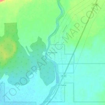
Name: Topografische Karte Box Canyon, Höhe, Relief.
Ort: Box Canyon, Fremont County, Idaho, United States (44.35721 -111.42534 44.39721 -111.38534)
Durchschnittliche Höhe: 1’891 m
Minimale Höhe: 1’871 m
Maximale Höhe: 1’948 m
Spenden
Rüste dich für dein nächstes Abenteuer:
Als Amazon-Partner verdient diese Seite an qualifizierten Käufen, ohne dass Ihnen zusätzliche Kosten entstehen.
Andere topografische Karten
Klicken Sie auf eine Karte, um ihre Topografie, ihre Höhe und ihr Relief anzuzeigen.
Island Park
United States > Idaho > Fremont County
Island Park is located at 44°29′59″N 111°20′19″W / 44.49972°N 111.33861°W / 44.49972; -111.33861 (44.4996, −111.3387), at an elevation of 6,293 feet (1,918 m) above sea level, making it the highest city in Idaho.
Durchschnittliche Höhe: 2’113 m
Ashton
United States > Idaho > Fremont County
Seed potatoes Ashton was first and foremost a farming community, as the soil of the area is rich and the water is plentiful. Shortly after the first settlers arrived in the 1890s, several canals were developed to divert water from streams running off the Yellowstone Plateau and Teton Range. Some farmland,…
Durchschnittliche Höhe: 1’601 m
Newdale
United States > Idaho > Fremont County
Newdale is the nearest city to the Teton Dam, which failed on June 5, 1976. Newdale did not receive any flooding or damage, due to its elevation and position relative to the dam.
Durchschnittliche Höhe: 1’550 m
Sand Mountain Wilderness Study Area
United States > Idaho > Fremont County
Durchschnittliche Höhe: 1’566 m
Spenden
Rüste dich für dein nächstes Abenteuer:
Als Amazon-Partner verdient diese Seite an qualifizierten Käufen, ohne dass Ihnen zusätzliche Kosten entstehen.
Newdale
United States > Idaho > Fremont County
Newdale is the nearest city to the Teton Dam, which failed on June 5, 1976. Newdale did not receive any flooding or damage, due to its elevation and position relative to the dam.
Durchschnittliche Höhe: 1’550 m
Island Park
United States > Idaho > Fremont County
Island Park is located at 44°29′59″N 111°20′19″W / 44.49972°N 111.33861°W / 44.49972; -111.33861 (44.4996, −111.3387), at an elevation of 6,293 feet (1,918 m) above sea level, making it the highest city in Idaho.
Durchschnittliche Höhe: 2’113 m