
Spenden
Rüste dich für dein nächstes Abenteuer:
Als Amazon-Partner verdient diese Seite an qualifizierten Käufen, ohne dass Ihnen zusätzliche Kosten entstehen.
Topografische Karte Checotah
Klicken Sie auf die Karte, um die Höhe anzuzeigen.
Spenden
Rüste dich für dein nächstes Abenteuer:
Als Amazon-Partner verdient diese Seite an qualifizierten Käufen, ohne dass Ihnen zusätzliche Kosten entstehen.
Checotah
Checotah is located at an elevation of 652 feet (199 m) at the intersection of I-40 and U.S. Route 69. Nearby is Eufaula Lake, the largest-capacity lake wholly within the state of Oklahoma.
Spenden
Rüste dich für dein nächstes Abenteuer:
Als Amazon-Partner verdient diese Seite an qualifizierten Käufen, ohne dass Ihnen zusätzliche Kosten entstehen.
Über diese Karte
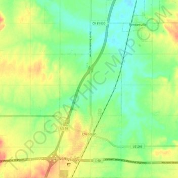
Name: Topografische Karte Checotah, Höhe, Relief.
Ort: Checotah, McIntosh County, Oklahoma, 74426, United States (35.44943 -95.54899 35.53302 -95.50439)
Durchschnittliche Höhe: 189 m
Minimale Höhe: 168 m
Maximale Höhe: 216 m
Spenden
Rüste dich für dein nächstes Abenteuer:
Als Amazon-Partner verdient diese Seite an qualifizierten Käufen, ohne dass Ihnen zusätzliche Kosten entstehen.
Andere topografische Karten
Klicken Sie auf eine Karte, um ihre Topografie, ihre Höhe und ihr Relief anzuzeigen.
Honey Springs Battlefield
United States > Oklahoma > McIntosh County > Rentiesville
Durchschnittliche Höhe: 185 m