
Topografische Karte High Pine
Interaktive Karte
Klicken Sie auf die Karte, um die Höhe anzuzeigen.
Über diese Karte
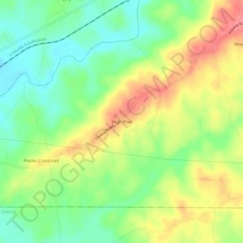
Name: Topografische Karte High Pine, Höhe, Relief.
Ort: High Pine, Randolph County, Alabama, United States (33.10290 -85.46301 33.14290 -85.42301)
Durchschnittliche Höhe: 235 m
Minimale Höhe: 196 m
Maximale Höhe: 285 m
Andere topografische Karten
Klicken Sie auf eine Karte, um ihre Topografie, ihre Höhe und ihr Relief anzuzeigen.
Wedowee Club Lake Dam
United States > Alabama > Randolph County
Wedowee Club Lake Dam, Randolph County, Alabama, United States
Durchschnittliche Höhe: 280 m
Wedowee
United States > Alabama > Randolph County
Wedowee, Randolph County, Alabama, United States
Durchschnittliche Höhe: 278 m
Roanoke
United States > Alabama > Randolph County
Roanoke, Randolph County, Alabama, 36274, United States
Durchschnittliche Höhe: 252 m
Flat Rock
United States > Alabama > Randolph County
Flat Rock, Randolph County, Alabama, United States
Durchschnittliche Höhe: 253 m
Melody Lane
United States > Alabama > Randolph County > Roanoke
Melody Lane, Roanoke, Randolph County, Alabama, 36274, United States
Durchschnittliche Höhe: 262 m
Woodland
United States > Alabama > Randolph County
Woodland, Randolph County, Alabama, 36280, United States
Durchschnittliche Höhe: 313 m
Newell
United States > Alabama > Randolph County > Newell
Newell, Randolph County, Alabama, 36270, United States
Durchschnittliche Höhe: 286 m
Wadley
United States > Alabama > Randolph County
Wadley, Randolph County, Alabama, United States
Durchschnittliche Höhe: 209 m
Roanoke
United States > Alabama > Randolph County > Roanoke
Roanoke, Randolph County, Alabama, 36274, United States
Durchschnittliche Höhe: 251 m