
Spenden
Rüste dich für dein nächstes Abenteuer:
Als Amazon-Partner verdient diese Seite an qualifizierten Käufen, ohne dass Ihnen zusätzliche Kosten entstehen.
Topografische Karte Epsom and Ewell
Klicken Sie auf die Karte, um die Höhe anzuzeigen.
Spenden
Rüste dich für dein nächstes Abenteuer:
Als Amazon-Partner verdient diese Seite an qualifizierten Käufen, ohne dass Ihnen zusätzliche Kosten entstehen.
Epsom and Ewell
The borough is at a range of elevations, scaling the lower slopes of the North Downs and drains into a large stream which springs above the surface in Ewell, the Hogsmill River which drains into the Thames at Kingston. The borough comprises.
Spenden
Rüste dich für dein nächstes Abenteuer:
Als Amazon-Partner verdient diese Seite an qualifizierten Käufen, ohne dass Ihnen zusätzliche Kosten entstehen.
Über diese Karte
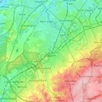
Name: Topografische Karte Epsom and Ewell, Höhe, Relief.
Ort: Epsom and Ewell, Surrey, England, United Kingdom (51.29233 -0.30621 51.38022 -0.21729)
Durchschnittliche Höhe: 73 m
Minimale Höhe: 12 m
Maximale Höhe: 181 m
Spenden
Rüste dich für dein nächstes Abenteuer:
Als Amazon-Partner verdient diese Seite an qualifizierten Käufen, ohne dass Ihnen zusätzliche Kosten entstehen.
Andere topografische Karten
Klicken Sie auf eine Karte, um ihre Topografie, ihre Höhe und ihr Relief anzuzeigen.
Box Hill
United Kingdom > England > Surrey > Mole Valley > Pixham
The 15.8 km (9.8 mi) Box Hill Olympic circuit is generally cycled in an anticlockwise direction and begins to the south of the village of Mickleham with an ascent of the hill via the Zig Zag Road. From the National Trust Visitor Centre, the route turns eastwards, running along the escarpment and through the…
Durchschnittliche Höhe: 105 m
Spenden
Rüste dich für dein nächstes Abenteuer:
Als Amazon-Partner verdient diese Seite an qualifizierten Käufen, ohne dass Ihnen zusätzliche Kosten entstehen.
Cooper's Hill Slopes
United Kingdom > England > Surrey > Borough of Runnymede > Englefield Green
Durchschnittliche Höhe: 38 m
Grandstand Road
United Kingdom > England > Surrey > Epsom and Ewell > Epsom
Durchschnittliche Höhe: 115 m
Spenden
Rüste dich für dein nächstes Abenteuer:
Als Amazon-Partner verdient diese Seite an qualifizierten Käufen, ohne dass Ihnen zusätzliche Kosten entstehen.
Redhill
United Kingdom > England > Surrey > Reigate and Banstead
To the north, the town joins with the village of Merstham, north of which there is a "wind gap" in the chalk hills of the North Downs, at an elevation of 120 metres (390 ft) above sea level, through which the A23 road heads in from London. Geologists have speculated that there may once have been a…
Durchschnittliche Höhe: 107 m
Spenden
Rüste dich für dein nächstes Abenteuer:
Als Amazon-Partner verdient diese Seite an qualifizierten Käufen, ohne dass Ihnen zusätzliche Kosten entstehen.
Englefield Green
United Kingdom > England > Surrey > Borough of Runnymede
Durchschnittliche Höhe: 48 m
Caterham
United Kingdom > England > Surrey > Tandridge
In 1840 Caterham contained a total of 477 residents (figures taken from that census, compiled in an 1848 topographical encyclopedia) and in 1848 468 acres (189 ha) of its 2,386 acres (966 ha) were common land. Similar to today, 175 acres (71 ha) mostly steeper acres were woodland.
Durchschnittliche Höhe: 157 m
Reigate
United Kingdom > England > Surrey > Reigate and Banstead
Reigate is in central Surrey, around 19 mi (30 km) south of central London and 9 mi (14 km) north of Gatwick Airport. The town is in the Vale of Holmesdale, below the North Downs escarpment. The average elevation in the centre is 80 m (260 ft) above ordnance datum (OD) and the area is drained by the Wallace…
Durchschnittliche Höhe: 100 m
Spenden
Rüste dich für dein nächstes Abenteuer:
Als Amazon-Partner verdient diese Seite an qualifizierten Käufen, ohne dass Ihnen zusätzliche Kosten entstehen.
Camberley
United Kingdom > England > Surrey > Surrey Heath
The Staff College, to the north of Camberley town centre, is part of the Joint Services Command and Staff College, which provides training and education for established officers in the British Armed Forces and civil servants in the Ministry of Defence. The institution has its origins in the Royal Military…
Durchschnittliche Höhe: 88 m
Spenden
Rüste dich für dein nächstes Abenteuer:
Als Amazon-Partner verdient diese Seite an qualifizierten Käufen, ohne dass Ihnen zusätzliche Kosten entstehen.
Spenden
Rüste dich für dein nächstes Abenteuer:
Als Amazon-Partner verdient diese Seite an qualifizierten Käufen, ohne dass Ihnen zusätzliche Kosten entstehen.
Gatton
United Kingdom > England > Surrey > Reigate and Banstead
Gatton's elevations range from 215m AOD, the highest elevation, along Fort Lane, a cul-de-sac off the intersection of Reigate Hill (M25 Junction 8) which leads to four homes over the boundary in Reigate, a radio transmitter station, and a water tower. On the A217 is the Bridge House Hotel, whose name refers to…
Durchschnittliche Höhe: 134 m
Rodborough Common
United Kingdom > England > Surrey > Waverley > Cramhurst
Durchschnittliche Höhe: 62 m
Spenden
Rüste dich für dein nächstes Abenteuer:
Als Amazon-Partner verdient diese Seite an qualifizierten Käufen, ohne dass Ihnen zusätzliche Kosten entstehen.
Margery
United Kingdom > England > Surrey > Reigate and Banstead > Lower Kingswood
Durchschnittliche Höhe: 155 m
Walton On The Hill
United Kingdom > England > Surrey > Reigate and Banstead
Durchschnittliche Höhe: 162 m
Spenden
Rüste dich für dein nächstes Abenteuer:
Als Amazon-Partner verdient diese Seite an qualifizierten Käufen, ohne dass Ihnen zusätzliche Kosten entstehen.
Spenden
Rüste dich für dein nächstes Abenteuer:
Als Amazon-Partner verdient diese Seite an qualifizierten Käufen, ohne dass Ihnen zusätzliche Kosten entstehen.
Spenden
Rüste dich für dein nächstes Abenteuer:
Als Amazon-Partner verdient diese Seite an qualifizierten Käufen, ohne dass Ihnen zusätzliche Kosten entstehen.
West Byfleet
United Kingdom > England > Surrey > Woking
The surface undulates gently from the west to the east, where West Byfleet's land is drained in the parish of Byfleet itself by the River Wey. Soil ranges from sandy acidic soil in the west to more alluvial soil in the east, underlain by a mixture of gravel and clay. Elevations range from 18m Above Ordnance…
Durchschnittliche Höhe: 26 m
Spenden
Rüste dich für dein nächstes Abenteuer:
Als Amazon-Partner verdient diese Seite an qualifizierten Käufen, ohne dass Ihnen zusätzliche Kosten entstehen.
Bagshot Park Mansion
United Kingdom > England > Surrey > Surrey Heath > Bagshot
Durchschnittliche Höhe: 76 m
Crawley Hill
United Kingdom > England > Surrey > Surrey Heath > Camberley
Durchschnittliche Höhe: 91 m
Spenden
Rüste dich für dein nächstes Abenteuer:
Als Amazon-Partner verdient diese Seite an qualifizierten Käufen, ohne dass Ihnen zusätzliche Kosten entstehen.
Chertsey
United Kingdom > England > Surrey > Borough of Runnymede
Samuel Lewis devotes one of his longest entries to the small town in his 1848 topographical guide to England.
Durchschnittliche Höhe: 22 m
Spenden
Rüste dich für dein nächstes Abenteuer:
Als Amazon-Partner verdient diese Seite an qualifizierten Käufen, ohne dass Ihnen zusätzliche Kosten entstehen.
Winkworth Arboretum
United Kingdom > England > Surrey > Waverley > Hascombe
Durchschnittliche Höhe: 111 m
Cranleigh Waters or Bramley Wey
United Kingdom > England > Surrey > Guildford > Shalford
Durchschnittliche Höhe: 52 m
Spenden
Rüste dich für dein nächstes Abenteuer:
Als Amazon-Partner verdient diese Seite an qualifizierten Käufen, ohne dass Ihnen zusätzliche Kosten entstehen.
Egham Wick
United Kingdom > England > Surrey > Borough of Runnymede > Englefield Green
Durchschnittliche Höhe: 55 m
Abinger Bottom
United Kingdom > England > Surrey > Mole Valley > Abinger
Durchschnittliche Höhe: 196 m
Spenden
Rüste dich für dein nächstes Abenteuer:
Als Amazon-Partner verdient diese Seite an qualifizierten Käufen, ohne dass Ihnen zusätzliche Kosten entstehen.
Pharaoh's Island
United Kingdom > England > Surrey > Borough of Spelthorne
Durchschnittliche Höhe: 14 m
Spenden
Rüste dich für dein nächstes Abenteuer:
Als Amazon-Partner verdient diese Seite an qualifizierten Käufen, ohne dass Ihnen zusätzliche Kosten entstehen.
Frimley Lodge Park
United Kingdom > England > Surrey > Surrey Heath > Frimley Green
Durchschnittliche Höhe: 80 m
Netherne-on-the-Hill
United Kingdom > England > Surrey > Reigate and Banstead
Durchschnittliche Höhe: 153 m
Spenden
Rüste dich für dein nächstes Abenteuer:
Als Amazon-Partner verdient diese Seite an qualifizierten Käufen, ohne dass Ihnen zusätzliche Kosten entstehen.
Upper Halliford
United Kingdom > England > Surrey > Borough of Spelthorne
Based on 1841 census statistics, Samuel Lewis (publisher) in his 1848 A topographical guide to England stated the population of the parish of Sunbury which included Charlton and Upper Halliford, an area of 2,580 acres (1,040 ha) was 1,828.
Durchschnittliche Höhe: 13 m
Spenden
Rüste dich für dein nächstes Abenteuer:
Als Amazon-Partner verdient diese Seite an qualifizierten Käufen, ohne dass Ihnen zusätzliche Kosten entstehen.
Hankley Common
United Kingdom > England > Surrey > Waverley > Thursley > Truxford
Durchschnittliche Höhe: 70 m
Spenden
Rüste dich für dein nächstes Abenteuer:
Als Amazon-Partner verdient diese Seite an qualifizierten Käufen, ohne dass Ihnen zusätzliche Kosten entstehen.
Spenden
Rüste dich für dein nächstes Abenteuer:
Als Amazon-Partner verdient diese Seite an qualifizierten Käufen, ohne dass Ihnen zusätzliche Kosten entstehen.
Lower Kingswood
United Kingdom > England > Surrey > Reigate and Banstead
Durchschnittliche Höhe: 170 m
Redhill Common
United Kingdom > England > Surrey > Reigate and Banstead > Redhill
Durchschnittliche Höhe: 92 m
Spenden
Rüste dich für dein nächstes Abenteuer:
Als Amazon-Partner verdient diese Seite an qualifizierten Käufen, ohne dass Ihnen zusätzliche Kosten entstehen.
St John's
United Kingdom > England > Surrey > Reigate and Banstead > Redhill
Durchschnittliche Höhe: 87 m
Abinger Roughs
United Kingdom > England > Surrey > Mole Valley > Abinger Hammer
Durchschnittliche Höhe: 141 m
Spenden
Rüste dich für dein nächstes Abenteuer:
Als Amazon-Partner verdient diese Seite an qualifizierten Käufen, ohne dass Ihnen zusätzliche Kosten entstehen.
Brookwood Country Park
United Kingdom > England > Surrey > Woking > Knaphill
Durchschnittliche Höhe: 47 m
Nork Park
United Kingdom > England > Surrey > Reigate and Banstead > Banstead
Durchschnittliche Höhe: 143 m
Spenden
Rüste dich für dein nächstes Abenteuer:
Als Amazon-Partner verdient diese Seite an qualifizierten Käufen, ohne dass Ihnen zusätzliche Kosten entstehen.
Spenden
Rüste dich für dein nächstes Abenteuer:
Als Amazon-Partner verdient diese Seite an qualifizierten Käufen, ohne dass Ihnen zusätzliche Kosten entstehen.
Queen Mary Reservoir
United Kingdom > England > Surrey > Borough of Spelthorne > Charlton
Durchschnittliche Höhe: 14 m
Lyn Mushroom Farm
United Kingdom > England > Surrey > Borough of Runnymede > Lyne
Durchschnittliche Höhe: 39 m
Spenden
Rüste dich für dein nächstes Abenteuer:
Als Amazon-Partner verdient diese Seite an qualifizierten Käufen, ohne dass Ihnen zusätzliche Kosten entstehen.