
Topografische Karte Ankara
Interaktive Karte
Klicken Sie auf die Karte, um die Höhe anzuzeigen.
Über diese Karte
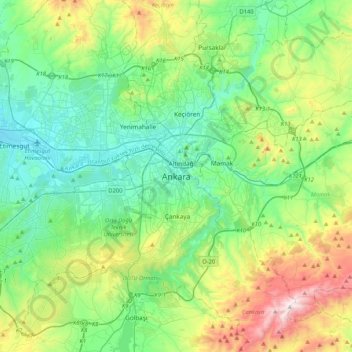
Name: Topografische Karte Ankara, Höhe, Relief.
Durchschnittliche Höhe: 1’082 m
Minimale Höhe: 798 m
Maximale Höhe: 1’864 m
Ankara has a cold semi-arid climate (Köppen climate classification: BSk). Under the Trewartha climate classification, Ankara has a temperate humid continental climate (Dc). Due to its elevation and inland location, Ankara has cold and snowy winters, and hot and dry summers. Rainfall occurs mostly during the spring and autumn. The city lies in USDA Hardiness zone 7b, and its annual average precipitation is fairly low at 414 millimeters (16 in), nevertheless precipitation can be observed throughout the year. Monthly mean temperatures range from 0.9 °C (33.6 °F) in January to 24.3 °C (75.7 °F) in July, with an annual mean of 12.6 °C (54.7 °F).
Andere topografische Karten
Klicken Sie auf eine Karte, um ihre Topografie, ihre Höhe und ihr Relief anzuzeigen.
Kocatepe Mahallesi
Kocatepe Mahallesi, Çankaya, Ankara, Central Anatolia Region, 06660, Turkey
Durchschnittliche Höhe: 896 m
Harbiye Mahallesi
Harbiye Mahallesi, Çankaya, Ankara, Central Anatolia Region, Turkey
Durchschnittliche Höhe: 1’004 m
Koru Mahallesi
Koru Mahallesi, Çankaya, Ankara, Central Anatolia Region, Turkey
Durchschnittliche Höhe: 900 m
Çayyolu Mahallesi
Çayyolu Mahallesi, Çankaya, Ankara, Central Anatolia Region, Turkey
Durchschnittliche Höhe: 921 m
Ayrancı Mahallesi
Ayrancı Mahallesi, Çankaya, Ankara, Central Anatolia Region, Turkey
Durchschnittliche Höhe: 975 m