
Topografische Karte Corpus Christi
Klicken Sie auf die Karte, um die Höhe anzuzeigen.
Corpus Christi
Corpus Christi features a diverse coastal topography characterized by its proximity to the Gulf of Mexico. The landscape includes sandy beaches, barrier islands, and extensive estuarine systems such as the Nueces Estuary and Corpus Christi Bay, which are crucial habitats for wildlife. The region is predominantly flat with elevations generally ranging from sea level to approximately 30 feet (9 meters) above sea level, making it prone to coastal influences and susceptible to flooding during storms. Additionally, the area is dotted with salt marshes and wetlands, contributing to its ecological richness while supporting a variety of marine and terrestrial species.
Über diese Karte
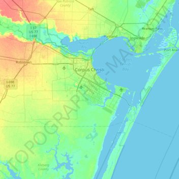
Name: Topografische Karte Corpus Christi, Höhe, Relief.
Ort: Corpus Christi, Nueces County, Texas, United States (27.48357 -97.68274 27.89964 -96.96111)
Durchschnittliche Höhe: 8 m
Minimale Höhe: -3 m
Maximale Höhe: 38 m
Andere topografische Karten
Klicken Sie auf eine Karte, um ihre Topografie, ihre Höhe und ihr Relief anzuzeigen.