
Spenden
Rüste dich für dein nächstes Abenteuer:
Als Amazon-Partner verdient diese Seite an qualifizierten Käufen, ohne dass Ihnen zusätzliche Kosten entstehen.
Topografische Karte Corona
Klicken Sie auf die Karte, um die Höhe anzuzeigen.
Spenden
Rüste dich für dein nächstes Abenteuer:
Als Amazon-Partner verdient diese Seite an qualifizierten Käufen, ohne dass Ihnen zusätzliche Kosten entstehen.
Über diese Karte
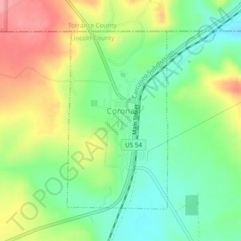
Name: Topografische Karte Corona, Höhe, Relief.
Ort: Corona, Lincoln County, New Mexico, 88318, United States (34.24007 -105.60401 34.25999 -105.59037)
Durchschnittliche Höhe: 2’055 m
Minimale Höhe: 2’013 m
Maximale Höhe: 2’116 m
Spenden
Rüste dich für dein nächstes Abenteuer:
Als Amazon-Partner verdient diese Seite an qualifizierten Käufen, ohne dass Ihnen zusätzliche Kosten entstehen.
Andere topografische Karten
Klicken Sie auf eine Karte, um ihre Topografie, ihre Höhe und ihr Relief anzuzeigen.
Ruidoso
United States > New Mexico > Lincoln County
Ruidoso is in southern Lincoln County, with elevations ranging from 6,400 feet (2,000 m) at the village's southeast corner in the valley of the Rio Ruidoso up to over 7,700 feet (2,300 m) at the village's northern end near Alto. Ruidoso's southern border and westernmost border follow the Otero County line. The…
Durchschnittliche Höhe: 2’287 m
Spenden
Rüste dich für dein nächstes Abenteuer:
Als Amazon-Partner verdient diese Seite an qualifizierten Käufen, ohne dass Ihnen zusätzliche Kosten entstehen.
Alto
United States > New Mexico > Lincoln County
Alto is located at an elevation of 7,550 feet (2,300 m) in the Lincoln National Forest, five miles (8.0 km) north of the village of Ruidoso. Alto received its name from the Spanish word "high" because of its elevation.
Durchschnittliche Höhe: 2’285 m
Capitan
United States > New Mexico > Lincoln County
Capitan is a village in Lincoln County, New Mexico, United States, located north of the Lincoln National Forest between the Capitan and Sacramento Mountains at an elevation of 6,350 feet (1,950 m). The population was 1,489 at the 2010 census. Capitan was founded in the 1890s and incorporated in 1941.
Durchschnittliche Höhe: 1’986 m
Ruidoso
United States > New Mexico > Lincoln County
Ruidoso is in southern Lincoln County, with elevations ranging from 6,400 feet (2,000 m) at the village's southeast corner in the valley of the Rio Ruidoso up to over 7,700 feet (2,300 m) at the village's northern end near Alto. Ruidoso's southern border and westernmost border follow the Otero County line. The…
Durchschnittliche Höhe: 2’287 m
Spenden
Rüste dich für dein nächstes Abenteuer:
Als Amazon-Partner verdient diese Seite an qualifizierten Käufen, ohne dass Ihnen zusätzliche Kosten entstehen.
Ruidoso
United States > New Mexico > Lincoln County
Ruidoso is in southern Lincoln County, with elevations ranging from 6,400 feet (2,000 m) at the village's southeast corner in the valley of the Rio Ruidoso up to over 7,700 feet (2,300 m) at the village's northern end near Alto. Ruidoso's southern border and westernmost border follow the Otero County line. The…
Durchschnittliche Höhe: 2’287 m
Carrizozo
United States > New Mexico > Lincoln County
To the west of the town is the Carrizozo Malpais, a 40-mile-long (64 km) lava flow that is about 1,500 years old and accessible through the Valley of Fires Recreation Area. To the northeast is Carrizo Mountain, a 9,600-foot (2,900 m) peak within the Sacramento Mountains, and to the southeast is the Sierra…
Durchschnittliche Höhe: 1’663 m
Ruidoso
United States > New Mexico > Lincoln County
Ruidoso is in southern Lincoln County, with elevations ranging from 6,400 feet (2,000 m) at the village's southeast corner in the valley of the Rio Ruidoso up to over 7,700 feet (2,300 m) at the village's northern end near Alto. Ruidoso's southern border and westernmost border follow the Otero County line. The…
Durchschnittliche Höhe: 2’287 m
Spenden
Rüste dich für dein nächstes Abenteuer:
Als Amazon-Partner verdient diese Seite an qualifizierten Käufen, ohne dass Ihnen zusätzliche Kosten entstehen.
Alto
United States > New Mexico > Lincoln County
Alto is located at an elevation of 7,550 feet (2,300 m) in the Lincoln National Forest, five miles (8.0 km) north of the village of Ruidoso. Alto received its name from the Spanish word "high" because of its elevation.
Durchschnittliche Höhe: 2’285 m
Ruidoso
United States > New Mexico > Lincoln County
Ruidoso is in southern Lincoln County, with elevations ranging from 6,400 feet (2,000 m) at the village's southeast corner in the valley of the Rio Ruidoso up to over 7,700 feet (2,300 m) at the village's northern end near Alto. Ruidoso's southern border and westernmost border follow the Otero County line. The…
Durchschnittliche Höhe: 2’287 m
Capitan
United States > New Mexico > Lincoln County
Capitan is a village in Lincoln County, New Mexico, United States, located north of the Lincoln National Forest between the Capitan and Sacramento Mountains at an elevation of 6,350 feet (1,950 m). The population was 1,489 at the 2010 census. Capitan was founded in the 1890s and incorporated in 1941.
Durchschnittliche Höhe: 1’986 m
Spenden
Rüste dich für dein nächstes Abenteuer:
Als Amazon-Partner verdient diese Seite an qualifizierten Käufen, ohne dass Ihnen zusätzliche Kosten entstehen.