
Topografische Karte Petritoli
Interaktive Karte
Klicken Sie auf die Karte, um die Höhe anzuzeigen.
Über diese Karte
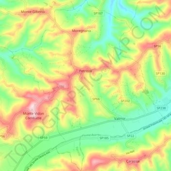
Name: Topografische Karte Petritoli, Höhe, Relief.
Ort: Petritoli, Fermo, Marche, 63848, Italy (43.02813 13.61922 43.09574 13.70122)
Durchschnittliche Höhe: 215 m
Minimale Höhe: 80 m
Maximale Höhe: 397 m
Andere topografische Karten
Klicken Sie auf eine Karte, um ihre Topografie, ihre Höhe und ihr Relief anzuzeigen.
Porto San Giorgio
Porto San Giorgio, Fermo, Marche, 63822, Italy
Durchschnittliche Höhe: 33 m
Montottone
Montottone, Fermo, Marche, 63843, Italy
Durchschnittliche Höhe: 220 m
Rovitolo
Italy > Marche > Fermo > Montefortino > Col Martese
Rovitolo, Col Martese, Montefortino, Fermo, Marche, 63858, Italy
Durchschnittliche Höhe: 586 m