
Spenden
Rüste dich für dein nächstes Abenteuer:
Als Amazon-Partner verdient diese Seite an qualifizierten Käufen, ohne dass Ihnen zusätzliche Kosten entstehen.
Topografische Karte Kavaratti
Klicken Sie auf die Karte, um die Höhe anzuzeigen.
Spenden
Rüste dich für dein nächstes Abenteuer:
Als Amazon-Partner verdient diese Seite an qualifizierten Käufen, ohne dass Ihnen zusätzliche Kosten entstehen.
Kavaratti
The atoll of Kavaratti lies 360 km (220 mi) off the Malabar coast of mainland India. The island is 5.6 km (3.5 mi) long, and 1.6 km (0.99 mi) wide, and occupies an area of 4.22 km2 (1.63 sq mi). It is surrounded by a 6 km (3.7 mi) long lagoon with an area of 4.96 km2 (1.92 sq mi). It is located to the east of Agatti and to the west of Andrott islands. The island gently slopes from the west to east, with an average altitude of 2 to 5 m (6 ft 7 in to 16 ft 5 in) on the west and 2 to 3 m (6 ft 7 in to 9 ft 10 in) on the eastern side. The soil is mostly sandy or loamy. Kavaratti has an inland lake in the northern part of the island and numerous small ponds and wells. The island is surrounded by coral reefs that support various marine life.
Spenden
Rüste dich für dein nächstes Abenteuer:
Als Amazon-Partner verdient diese Seite an qualifizierten Käufen, ohne dass Ihnen zusätzliche Kosten entstehen.
Über diese Karte
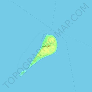
Name: Topografische Karte Kavaratti, Höhe, Relief.
Ort: Kavaratti, Lakshadweep, 262240, India (10.52722 72.59946 10.60722 72.67946)
Durchschnittliche Höhe: 0 m
Minimale Höhe: 0 m
Maximale Höhe: 17 m
Spenden
Rüste dich für dein nächstes Abenteuer:
Als Amazon-Partner verdient diese Seite an qualifizierten Käufen, ohne dass Ihnen zusätzliche Kosten entstehen.
Andere topografische Karten
Klicken Sie auf eine Karte, um ihre Topografie, ihre Höhe und ihr Relief anzuzeigen.
Kavaratti Island
India > Lakshadweep > Kavaratti > Kavaratti
The island of Kavaratti lies 360 km (190 nmi) off the coast of the state of Kerala at 10°34′N 72°38′E / 10.57°N 72.64°E / 10.57; 72.64. It has an average elevation of 0 metres (0 feet).
Durchschnittliche Höhe: 2 m