
Spenden
Rüste dich für dein nächstes Abenteuer:
Als Amazon-Partner verdient diese Seite an qualifizierten Käufen, ohne dass Ihnen zusätzliche Kosten entstehen.
Topografische Karte Munsyari
Klicken Sie auf die Karte, um die Höhe anzuzeigen.
Spenden
Rüste dich für dein nächstes Abenteuer:
Als Amazon-Partner verdient diese Seite an qualifizierten Käufen, ohne dass Ihnen zusätzliche Kosten entstehen.
Über diese Karte
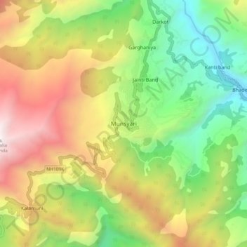
Name: Topografische Karte Munsyari, Höhe, Relief.
Durchschnittliche Höhe: 2’306 m
Minimale Höhe: 1’236 m
Maximale Höhe: 3’746 m
Spenden
Rüste dich für dein nächstes Abenteuer:
Als Amazon-Partner verdient diese Seite an qualifizierten Käufen, ohne dass Ihnen zusätzliche Kosten entstehen.
Andere topografische Karten
Klicken Sie auf eine Karte, um ihre Topografie, ihre Höhe und ihr Relief anzuzeigen.
Milam Glacier
India > Uttarakhand > Munsiari tehsil
Milam Glacier, covering around 37 km2 (14 sq mi) area of 16 km (10 mi) length, is located about 15 kilometres (9 mi) northeast of Nanda Devi. It ranges in elevation from about 5,500 metres (18,000 ft) to about 3,870 metres (12,700 ft) at its snout. Situated on the south facing slope of the main Great Himalayas…
Durchschnittliche Höhe: 5’229 m
Milam Glacier
India > Uttarakhand > Munsiari tehsil
The Bhotiya communities living in the Pithoragarh district historically practised transhumance between summer villages located at higher altitudes, close to the border with Tibet, and winter settlements located at lower altitudes, close to the Himalayan foothills and the Gangetic plains. With transhumance as a…
Durchschnittliche Höhe: 5’229 m