
Spenden
Rüste dich für dein nächstes Abenteuer:
Als Amazon-Partner verdient diese Seite an qualifizierten Käufen, ohne dass Ihnen zusätzliche Kosten entstehen.
Topografische Karte Salvo
Klicken Sie auf die Karte, um die Höhe anzuzeigen.
Spenden
Rüste dich für dein nächstes Abenteuer:
Als Amazon-Partner verdient diese Seite an qualifizierten Käufen, ohne dass Ihnen zusätzliche Kosten entstehen.
Über diese Karte
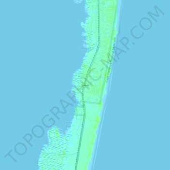
Name: Topografische Karte Salvo, Höhe, Relief.
Ort: Salvo, Dare County, North Carolina, 27972, United States (35.52018 -75.49293 35.56018 -75.45293)
Durchschnittliche Höhe: 1 m
Minimale Höhe: -1 m
Maximale Höhe: 8 m
Spenden
Rüste dich für dein nächstes Abenteuer:
Als Amazon-Partner verdient diese Seite an qualifizierten Käufen, ohne dass Ihnen zusätzliche Kosten entstehen.
Andere topografische Karten
Klicken Sie auf eine Karte, um ihre Topografie, ihre Höhe und ihr Relief anzuzeigen.
Kill Devil Hills
United States > North Carolina > Dare County
First Flight Airport covers an area of 40 acres at an elevation of 13 feet (4 metres) above mean sea level. It has one runway; designated 2/20, with an asphalt surface measuring 3,000 by 60 feet (914 by 18 metres). For the 12-month period ending August 19, 2009, the airport had 38,120 aircraft operations, an…
Durchschnittliche Höhe: 2 m
Spenden
Rüste dich für dein nächstes Abenteuer:
Als Amazon-Partner verdient diese Seite an qualifizierten Käufen, ohne dass Ihnen zusätzliche Kosten entstehen.
Cape Hatteras National Seashore
United States > North Carolina > Dare County > Nags Head
Durchschnittliche Höhe: 0 m
Spenden
Rüste dich für dein nächstes Abenteuer:
Als Amazon-Partner verdient diese Seite an qualifizierten Käufen, ohne dass Ihnen zusätzliche Kosten entstehen.
Kill Devil Hills
United States > North Carolina > Dare County
First Flight Airport covers an area of 40 acres at an elevation of 13 feet (4 metres) above mean sea level. It has one runway; designated 3/21, with an asphalt surface measuring 3,000 by 60 feet (914 by 18 metres). For the 12-month period ending August 19, 2009, the airport had 38,120 aircraft operations, an…
Durchschnittliche Höhe: 2 m
Spenden
Rüste dich für dein nächstes Abenteuer:
Als Amazon-Partner verdient diese Seite an qualifizierten Käufen, ohne dass Ihnen zusätzliche Kosten entstehen.
Kitty Hawk
United States > North Carolina > Dare County
Kitty Hawk is located at 36°06′N 75°42′W / 36.1°N 75.7°W / 36.1; -75.7 at an elevation of 7 feet (2 m) above sea level.
Durchschnittliche Höhe: 2 m
Spenden
Rüste dich für dein nächstes Abenteuer:
Als Amazon-Partner verdient diese Seite an qualifizierten Käufen, ohne dass Ihnen zusätzliche Kosten entstehen.
Kill Devil Hills
United States > North Carolina > Dare County
First Flight Airport covers an area of 40 acres at an elevation of 13 feet (4 metres) above mean sea level. It has one runway; designated 2/20, with an asphalt surface measuring 3,000 by 60 feet (914 by 18 metres). For the 12-month period ending August 19, 2009, the airport had 38,120 aircraft operations, an…
Durchschnittliche Höhe: 2 m
Cape Hatteras National Seashore
United States > North Carolina > Dare County > Nags Head
Durchschnittliche Höhe: 0 m