
Topografische Karte Birken
Klicken Sie auf die Karte, um die Höhe anzuzeigen.
Über diese Karte
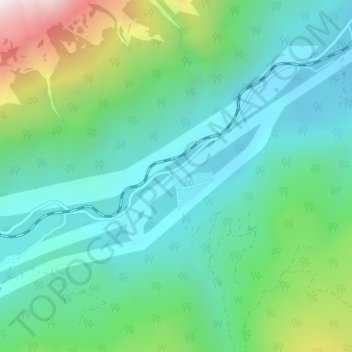
Name: Topografische Karte Birken, Höhe, Relief.
Durchschnittliche Höhe: 796 m
Minimale Höhe: 386 m
Maximale Höhe: 2’213 m
Andere topografische Karten
Klicken Sie auf eine Karte, um ihre Topografie, ihre Höhe und ihr Relief anzuzeigen.
Lillooet Lake
Canada > British Columbia > Squamish-Lillooet Regional District > Area C (Pemberton Valley/Mount Currie/D'Arcy)
Durchschnittliche Höhe: 1’177 m
Joffre Lakes Provincial Park
Canada > British Columbia > Squamish-Lillooet Regional District > Area C (Pemberton Valley/Mount Currie/D'Arcy)
Staying on the trail is important for the preservation of the park environment, and for the safety of hikers. Lower Joffre Lake is a short distance away from the parking lot with no elevation gain. The trail to Middle and Upper Joffre lakes however is more challenging due to the greater elevation gain. Hiking…
Durchschnittliche Höhe: 1’911 m
Birkenhead Lake Provincial Park
Canada > British Columbia > Squamish-Lillooet Regional District > Area C (Pemberton Valley/Mount Currie/D'Arcy)
Durchschnittliche Höhe: 1’558 m
Lillooet Glacier
Canada > British Columbia > Squamish-Lillooet Regional District > Area C (Pemberton Valley/Mount Currie/D'Arcy)
Durchschnittliche Höhe: 2’171 m
Bishop Glacier
Canada > British Columbia > Squamish-Lillooet Regional District > Area C (Pemberton Valley/Mount Currie/D'Arcy)
Durchschnittliche Höhe: 1’932 m
Overlord Glacier
Canada > British Columbia > Squamish-Lillooet Regional District > Area C (Pemberton Valley/Mount Currie/D'Arcy)
Durchschnittliche Höhe: 2’133 m
Birkenhead Lake Provincial Park
Canada > British Columbia > Squamish-Lillooet Regional District > Area C (Pemberton Valley/Mount Currie/D'Arcy)
Durchschnittliche Höhe: 1’558 m
Joffre Lakes Provincial Park
Canada > British Columbia > Squamish-Lillooet Regional District > Area C (Pemberton Valley/Mount Currie/D'Arcy)
Staying on the trail is important for the preservation of the park environment, and for the safety of hikers. Lower Joffre Lake is a short distance away from the parking lot with no elevation gain. The trail to Middle and Upper Joffre lakes however is more challenging due to the greater elevation gain. Hiking…
Durchschnittliche Höhe: 1’911 m
Needles Glacier
Canada > British Columbia > Squamish-Lillooet Regional District > Area C (Pemberton Valley/Mount Currie/D'Arcy)
Durchschnittliche Höhe: 2’126 m